
Abstract
Fires, explosions, and spills at petrochemical industry facilities create air pollution exposure risks for surrounding residences, which are disproportionately communities of color and low-income communities. This study analyzed local air pollution before, during, and after a 2019 industrial fire at the International Terminals Company's Deer Park facility in Houston, Texas. Meteorological conditions and pollution data from handheld, vehicular, and stationary monitors were analyzed. The fire produced elevated pollution levels in nearby residential areas. After the fire, benzene concentrations reached levels of concern for human health; particulate matter levels did not. Monitoring data gaps limited our ability to assess potential health effects of the fire; however, this does not suggest that industrial fires have minimal or no impacts on community exposure. In the absence of monitoring data, public health threats can be assessed by studying the scale of the incident, chemicals involved, meteorological conditions, and proximity to residential areas. The air pollution exposure and health effects of acute industrial emissions events can be significant but are not often captured by existing monitoring networks. Regulators and petrochemical companies can take steps to minimize the risk of industrial incidents and better monitor and convey risks to communities.
INTRODUCTION
Since at least the 1980s, environmental justice research has documented disproportionately high exposures to environmental hazards in communities of color and low-income communities 1 , 2 , 3 and several studies have documented such inequities in exposure to and health effects from air pollution attributed to industrial facilities in Houston and elsewhere. 4 , 5 Chemical facility pollution creates enormous health burdens on fenceline communities (characterized as communities adjacent to often-heavily polluting industrial facilities or military bases), 6 increasing the risk of infant mortality, 7 lung function in children, 8 and cancer deaths. 9 In addition to routine emissions, acute releases, explosions, and spills at chemical facilities can endanger nearby residents' health and safety. 10 , 11 Short-term spikes in concentrations of pollutants from industrial emissions, including particulate matter and hazardous air pollutants (HAPs), have been associated with adverse health effects, including respiratory and cardiovascular disease. 12 , 13
Acute emissions events are frequent in the Houston area. 14 , 15 On average, a large incident occurs at a Houston petrochemical facility every 6 weeks; smaller incidents occur more frequently. 16 This is exacerbated by frequent and unauthorized air pollution releases from industrial startup, shutdown, and malfunction processes 17 and the state of Texas' failure to levy penalties and implement other enforcement measures. 18 One study found that a few massive events account for most industrial facility emissions and, overall, excess emissions in Texas result in $150 million in health damages annually. 19
Because fenceline communities predominantly comprise low-income residents and people of color, acute emissions events contribute to environmental injustice and exacerbate pollution exposure inequities between fenceline communities and those further from facilities, which tend to be wealthier and whiter. 20 , 21 The spatial distribution of chronic and acute air pollution risks in the Greater Houston region disproportionately impacts Black and Latinx communities. 22 Because fenceline communities also tend to face other socioeconomic challenges, including limited access to quality health care and systemic racism, residents are often burdened with cumulative environmental stressors. 23
Houston communities face additional risks from hurricane-induced flooding that can compound and intensify the effects of industrial environmental hazards on communities. After Hurricane Harvey in 2017, Houston residents experienced a cascade of events that concentrated toxic chemicals, including polycyclic aromatic hydrocarbons, in environmental justice communities. 24 Further, the state and local government's response to Hurricane Harvey disproportionately disenfranchised Houston's low-income communities and communities of color at every stage of disaster mitigation, response, and recovery. 25
A few studies have assessed the degree to which existing monitoring networks capture community exposure, and a few have studied how much, and how quickly, relevant information is shared with affected communities. Here, we assess the air pollution impacts of an industrial fire at the International Terminals Company (ITC) Deer Park facility as well as the gaps in monitoring and public access that limit the availability of information to nearby residents, emergency responders, and public officials. Prior research suggests that the fire caused an increase in reported respiratory symptoms in Deer Park residents. 26
Around 10 am on March 17, 2019, a fire broke out at the ITC Deer Park Chemical Plant in Harris County, Texas. The fire spread to several chemical tanks containing naphtha and xylene (used to make gasoline products) and toluene (used in oil refining and the manufacturing of paints, lacquers, explosives, and glues, as well as in paint thinners, nail polish, glues, inks, and stain removers). The fire was extinguished 3 am on March 20, nearly 3 days later. At 5 pm, a tank reignited but the fire was put out within minutes. 27
The fire released a massive black smoke plume, which was visible throughout the Houston region. The plume contained 1-butene, isoprene, acetone, and other harmful chemicals. 28 When the Texas Commission on Environmental Quality's (TCEQ) air monitors detected dangerously high benzene levels, local government officials ordered Deer Park and Galena Park residents to shelter-in-place March 17–21. At noon on March 22, a breach in a containment wall caused three tanks to reignite. Vast quantities of chemicals from the tanks leaked into Tucker Bayou (a local stream that runs into the Gulf of Mexico), along with firefighting foam and water used to extinguish the flames. 29 This caused a localized increase in volatile organic compounds (VOCs), which led to a shelter-in-place order for local industrial plants and areas near the San Jacinto Monument State Park. The fire and breach were contained by 6 pm that day.
METHODS
We assessed all publicly available air pollution monitoring data before, during, and after the 2019 ITC Deer Park chemical fire. The analysis focused on pollutants with significant health effects, including fine particulate matter (PM2.5); HAPs including benzene, toluene, ethylene, and xylene (compounds known as BTEX); and other air pollutants, such as hydrogen sulfide, sulfur dioxide, 1,3-butadiene, and isoprene. HAPs and other gases were measured by using Automated Gas Chromatographs at TCEQ stationary sites and using specialized handheld devices for incident-specific surveys. Additional methods details can be found in Table 1. Measured concentrations were compared with health-based standards from state and federal authorities (Table 2). Hourly wind speed and direction data from TCEQ stationary monitors were used to develop wind rose plots at select monitoring locations.
Air Pollutant Monitoring Stations Assessed
Fine particulate matter.
AutoGC, automated gas chromatographs; EPA FRM, U.S. Environmental Protection Agency Federal Reference Method; HAPs, hazardous air pollutants; ITC, International Terminals Company; TCEQ, Texas Commission on Environmental Quality.
Benzene, Toluene, Ethylene, Xylene, and PM2.5 Exposure Levels Considered Harmful to Human Health
AMCV, air monitoring comparison value; ATSDR, Agency for Toxic Substances and Disease Registry; EPA, U.S. Environmental Protection Agency; NAAQS, national ambient air quality standards.
To assess air pollution impacts in residential areas, forward wind trajectories were modeled during the time period of the fire. Forward trajectories use meteorological modeling to assess potential pathways that specific air masses take over time. Trajectories were computed by using NOAA HYSPLIT, 30 with meteorological data from the High-Resolution Rapid Refresh model, and were assessed every 12 hours during the fire and 24 hours after, at both ground-level and 3000-foot elevation. Spatial analysis of demographic data in proximity to and downwind of the fire was performed at the census block level.
RESULTS
Meteorological assessment
We developed wind rose plots and forward wind trajectories to assess the potential for stationary monitors to have been downwind of the fire (Figs. 1–3). At ground level, the wind was generally blowing west or southwest from the ITC facility toward the city of Deer Park and the Harrisburg and Manchester neighborhoods. This could explain the elevated levels of PM2.5 and benzene in Deer Park and elsewhere and suggests that the shelter-in-place orders issued in Houston neighborhoods were warranted. Although there were a few residential areas in the 5 miles around the ITC facility, communities downwind of the fire had slightly higher percentages (53%) of Black, Indigenous, and people of color than the rest of Houston (51%) (Fig. 3).
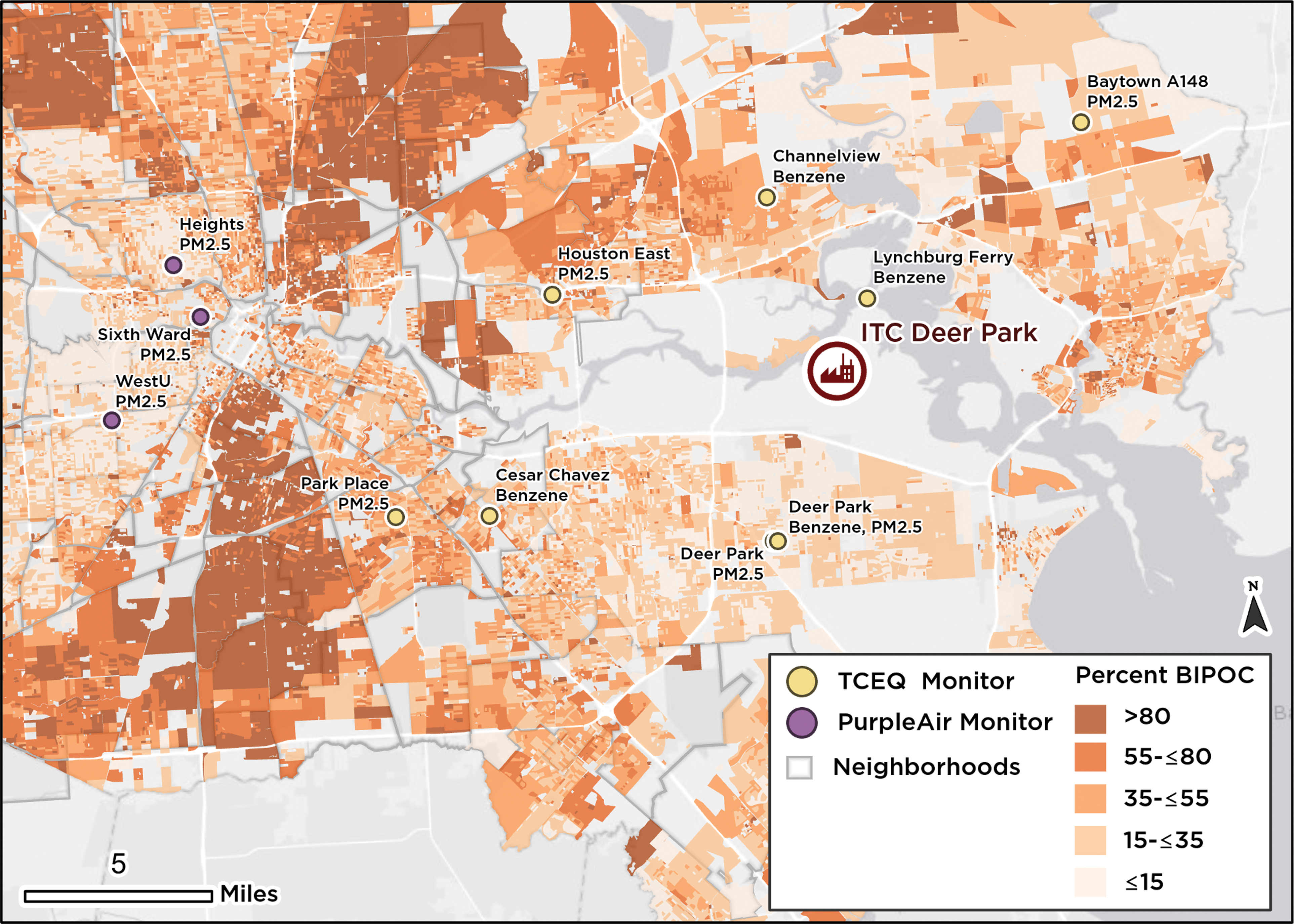
Fire location and nearby stationary monitors for benzene and particulate matter. The TCEQ monitors measured particulate matter, as well as benzene and other hazardous air pollutants at stations in neighborhoods near the fire. In addition, PurpleAir monitors provided particulate matter data in three locations near central Houston. Shading shows the percent of the population that is Black, Indigenous, and people of color by census block. ITC, International Terminals Company; TCEQ, Texas Commission on Environmental Quality. Color images are available online.
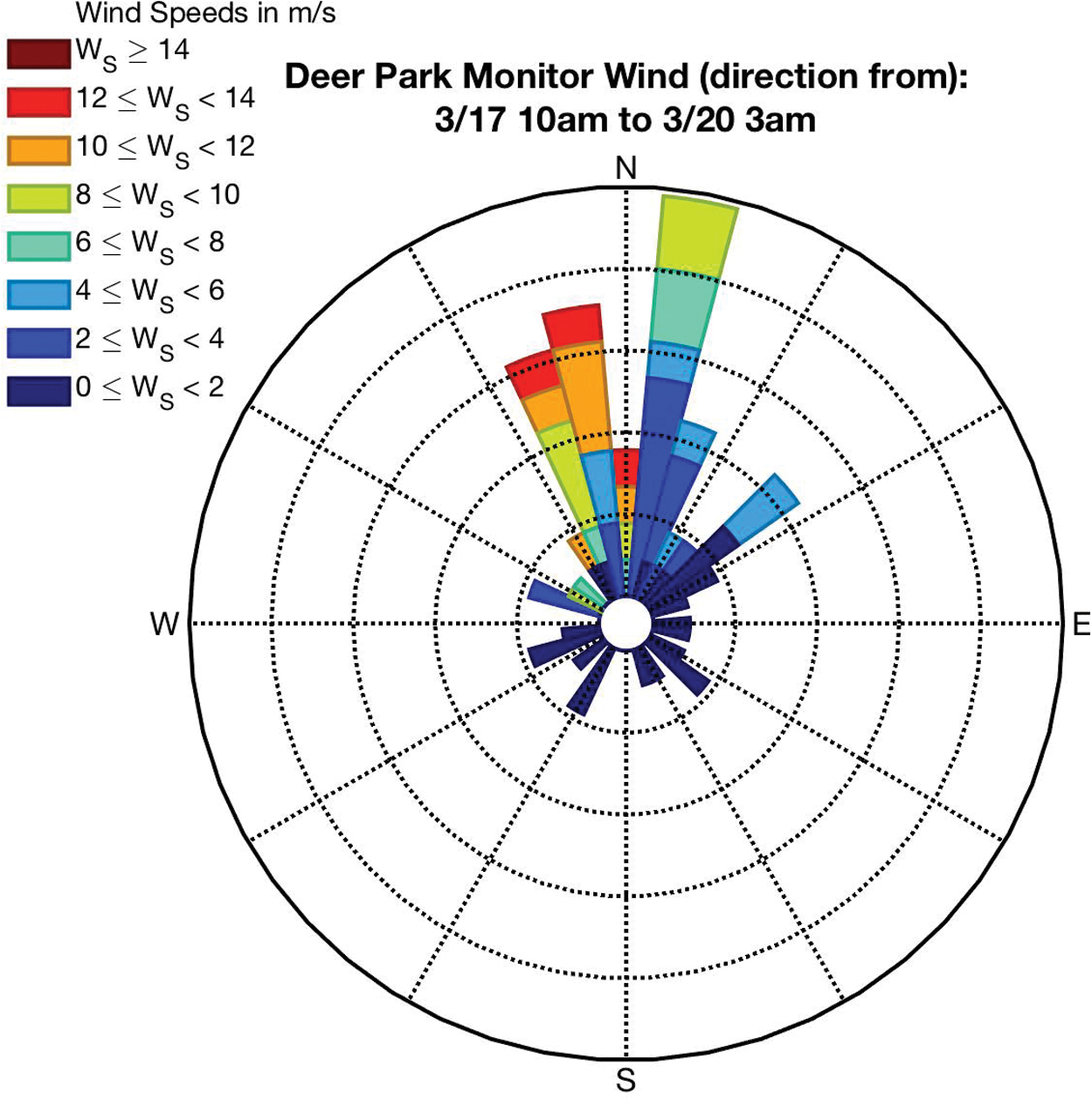
Wind rose plot of Deer Park Monitor. Wind rose plot displaying the frequency of wind direction origin and speed at the Deer Park monitor from 10 am on March 17 to 3 am March 20. Color images are available online.
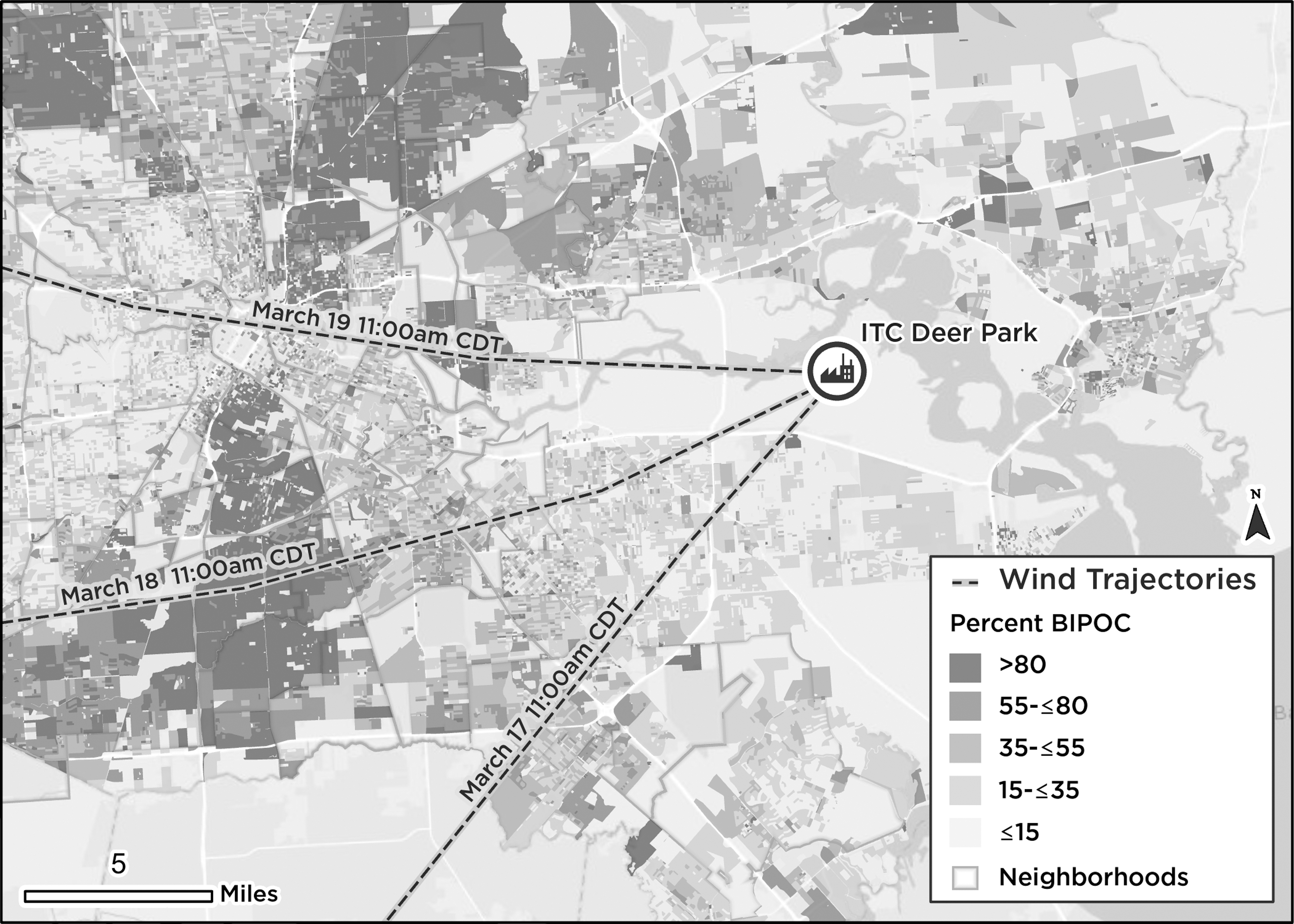
Forward wind trajectories. Forward trajectories of air at ground level originating at the ITC plant March 17–19 indicate the potential for stationary monitors to capture fire-related air pollution. The trajectories were calculated by using the HRRR meteorological model and plotted at 11 am CDT, the hour after the fire began. Shading shows the percent of the population that is Black, Indigenous, and people of color by census block. CDT, central daylight time; HRRR, high-resolution rapid refresh.
Since the fire's smoke plume reached heights of 2000–5000 feet, we also modeled wind trajectories at 3000 feet. At this height, most wind trajectories showed air blowing away from Houston and into the bayou. However, the trajectories showed air flowing throughout Houston from the morning of March 18 to the morning of March 19, when the fire was consistently burning and corroborating observations of the black smoke plume visible throughout Houston and extending west of the city.
On March 20, wind trajectories showed air flowing from the ITC plant toward Houston, especially southeast and into Deer Park at 5–10 m/s. At that point, many hazardous gases—such as benzene, toluene, naphtha, and other HAPs—would have been released into the air and spread.
Hazardous air pollutants
We found elevated levels of benzene, toluene, ethylene, and xylene at the TCEQ Deer Park monitor (Fig. 4a, b). On March 21, benzene levels rose to 191 ppb, more than 500 times the average yearly concentration at that monitor of 0.34 ppb—and exceeding the TCEQ's short-term Air Monitoring Comparison Values (AMCVs of 180 ppb), screening levels used to assess the potential for health or welfare effects from outdoor airborne chemical concentrations (Table 2). The spike was the highest benzene concentration recorded at the Deer Park monitor in 2019 (Fig. 5).
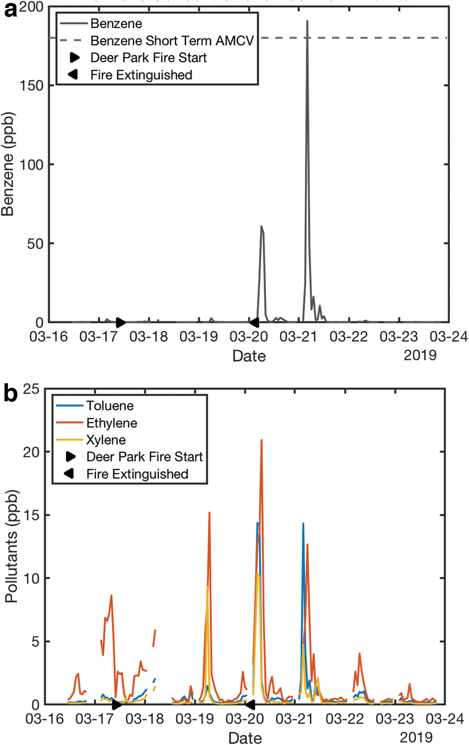
Hourly mixing ratios of
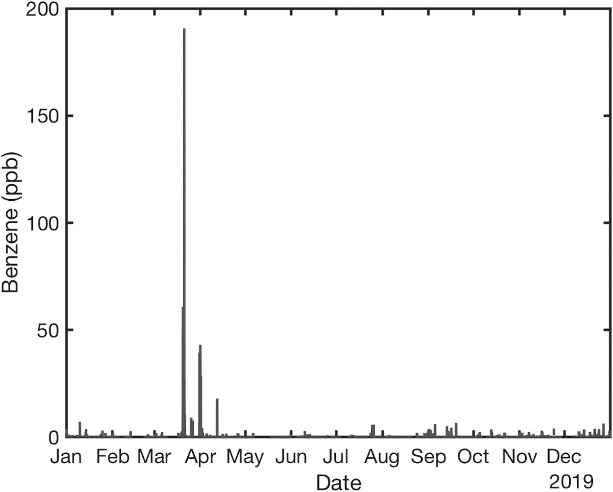
Hourly benzene mixing ratios for the entire 2019 year at the TCEQ Deer Park monitor. The TCEQ Deer Park monitor measured its highest levels of hourly benzene for 2019 in the days after the ITC fire.
Although TCEQ's short-term AMCVs are considered more health-protective than the U.S. Environmental Protection Agency (EPA)'s Acute Exposure Guideline Levels—used by emergency responders to examine human health effects from short-term exposure to airborne chemicals—it is less protective than other air toxic metrics. 31 For instance, California's air quality threshold triggers a shelter-in-place when benzene levels reach 10 ppb; Texas' short-term AMCV would trigger a shelter-in-place only if benzene levels were 18 times higher (180 ppb). In addition, cumulative risks from multiple pollutant exposures are not currently addressed in AMCVs.
During and for days after the fire, other nearby TCEQ monitors (Lynchburg Ferry, Channelview, and Cesar Chavez) recorded elevated levels of benzene (Fig. 6). The Lynchburg Ferry monitor (<10 miles northeast of the ITC facility) recorded elevated benzene levels of 165.17 ppb on March 20, 176.14 ppb on March 25, and 196.94 ppb on March 30, despite benzene levels at this monitor routinely staying below 1 ppb, with peaks around 10 ppb. The March 30 spike was the 2019 maximum and 500 times its annual average. On April 14, almost a month after the ITC fire started, the monitor recorded just over 100 ppb. The origin of that spike is uncertain.
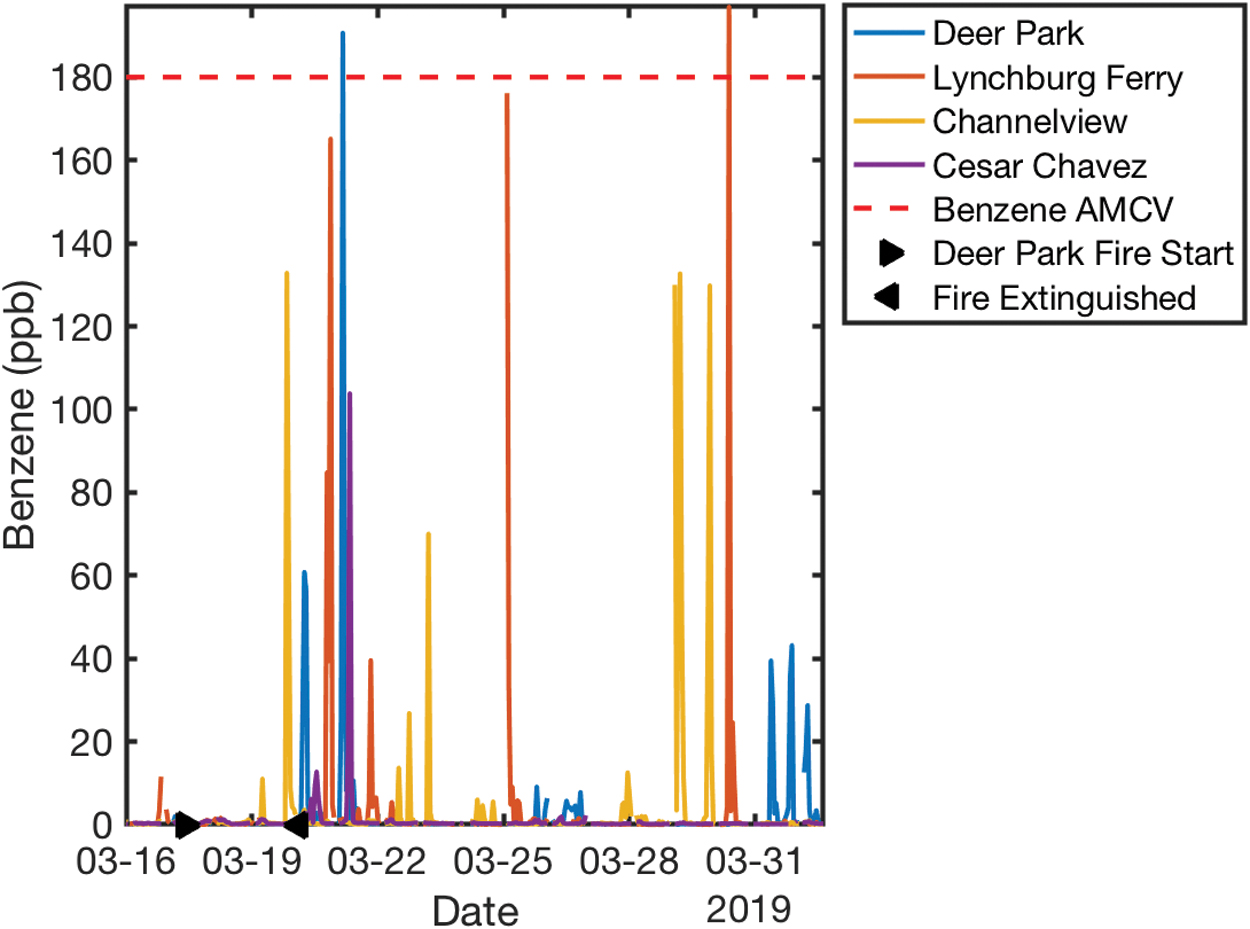
Hourly benzene mixing ratios from March 16 to April 1 at select TCEQ monitors. Several monitors in the vicinity of the plant measured hourly benzene mixing ratio spikes. Color images are available online.
The Cesar Chavez monitor, the closest monitor to the Harrisburg and Manchester neighborhoods and that typically measures benzene levels below 1 ppb, detected benzene levels above 100 ppb 24 hours after the fire had been extinguished.
Handheld monitoring devices used in the plant's vicinity detected benzene levels that exceeded TCEQ's AMCV for more than 2 weeks after the fire. These spikes occurred in 7 of 20 days (35%) of monitoring in late March and early April. Most of these elevated levels were measured within the industrial area, but on several days, spikes were found north of the plant, in the residential area of Channelview, and to the south in Deer Park.
The TCEQ and EPA handheld and van monitoring near the facility and in farther residential communities corroborated industry-led and stationary source findings. On 9 of 19 days of measurements, benzene levels in Deer Park, Channelview, Baytown, and the industrial area exceeded the Centers for Disease Control and Prevention's Agency for Toxic Substances and Disease Registry (ATSDR) minimal risk level of 9 ppb and TCEQ's short-term AMCV of 180 ppb. The highest levels of benzene observed in the industrial area (32,000 ppb on March 21 and 11,000 ppb on March 31) temporally aligned with the highest concentrations observed at the Deer Park monitor (2800 ppb on March 21 and 2500 ppb on March 31), suggesting that it may have been downwind of the plant. This is also supported by the meteorological assessment. The benzene spikes in Deer Park on March 21 were measured in community areas, including near an elementary school and church, and exceeded TCEQ's short-term AMCV by a factor of 3 to 16.
Handheld and van-based monitors detected VOC levels above 5000 ppb in communities surrounding the ITC plant (Deer Park, Baytown, Highlands, and Central Houston, including near four schools). These measurements could not be conclusively attributed to the fire because they were comparable to background levels caused by traffic emissions, chronic industrial emissions, and other sources. However, one study found an increase in reported respiratory symptoms—including persistent coughing and nose, eye, and throat irritation—for residents of Deer Park during and 2 weeks after the fire. 32
The EPA's ASPECT aircraft—which performed daily flyovers—detected levels of several VOCs, including 1,3-butadiene, isoprene, and benzene, that exceeded TCEQ's short-term AMCV in residential areas. In many locations, ASPECT detected acetone levels that were elevated but below values of concern for health. The only values the EPA reported above the short-term AMCV were isoprene (1000 ppb) on the night of March 20, and isoprene (20 ppb) and 1,3-butadiene (1700 ppb) on March 22.
Many benzene readings recorded by EPA's TAGA exceeded TCEQ's short-term AMCV, 33 including some detected in the residential areas of Channelview and Deer Park. However, TAGA has limitations. The EPA's Inspector General has noted that, “TAGA's sampling time frame [which averaged data for only 1–2 seconds] was too short to generate data that could accurately assess airborne toxin concentrations for making health-based assessments.” 34
Fine particulate matter
We assessed PM2.5 levels by using TCEQ monitors and PurpleAir community monitors (West University, Sixth Ward, and the Heights). PurpleAir monitors are neither professionally operated nor used for regulatory purposes, and they tend to measure slightly higher levels of PM2.5 than regulatory monitors, but provide education and awareness, can capture trends, and provide additional geographic coverage in this analysis. The monitors maintained by the EPA and TCEQ are aging 35 and sometimes fail to capture spikes recorded by community-owned air sensors. 36 In some cases, it may be difficult to determine whether high spikes represented hazardous conditions or erroneous data collected by PurpleAir monitors.
The TCEQ Deer Park and Baytown monitors recorded elevated PM2.5 levels after the fire, with the highest hourly spikes observed on March 21 and 22 at 45 and 50 μg/m 3 at Deer Park and Baytown, respectively, more than five times the monitors' 2019 annual PM2.5 averages (Fig. 7). PM2.5 levels measured by the three PurpleAir monitors were much higher than usual, with several spikes in 80 second durations reaching levels considered “unhealthy” by the EPA's Air Quality Index (80–140 μg/m 3 ). 37 However, PM2.5 levels were elevated in the days before the fire, suggesting that they may not be attributable to the fire alone. The ITC-commissioned handheld monitoring found PM2.5 levels exceeding EPA's 24-hour standard (35 μg/m 3 ) for 4 of 20 days of monitoring (20%).
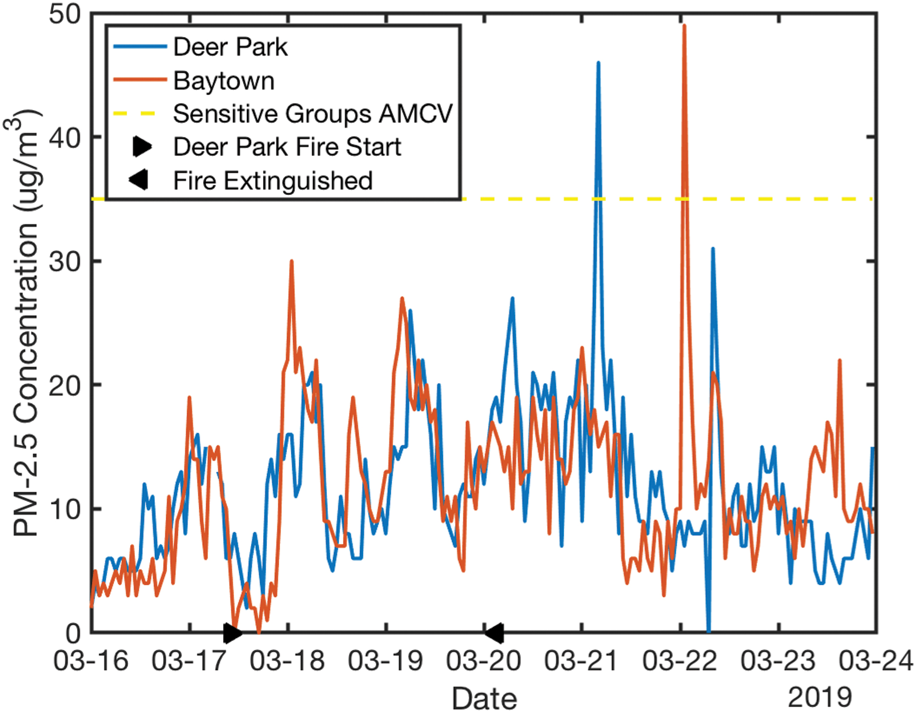
PM2.5 at TCEQ Deer Park and Baytown monitors, March 16–24. After the fire was extinguished, nearby stationary monitors measured fine particulate matter concentrations above the health-based standards set by the EPA and TCEQ, with concentration spikes observed March 21 at Deer Park (45 μg/m 3 ) and March 22 at Baytown (50 μg/m 3 ). These concentration spikes were five times higher than annual averages at respective monitors. (Annual averages were 8 and 9 μg/m 3 at Deer Park and Baytown monitors, respectively). EPA, Environmental Protection Agency; TCEQ, Texas Commission on Environmental Quality. Color images are available online.
Other pollutants
We analyzed air pollutant data that TCEQ and EPA collected with bus and van monitors over 26 days (March 17–April 12) in several industrial and community locations. On 13 of the 26 days, at least one location reported elevated levels of hydrogen sulfide, sulfur dioxide, butadiene, propane, benzene, xylene, ethylene, ethyl benzene, na-butane, toluene, hexane, cyclohexane, propylene, or ethane. Hydrogen sulfide concentrations (69.7–119.2 ppb), taken March 22 in a Jacintoport Boulevard industrial area, exceeded the ATSDR minimal risk level (70 ppb). Hydrogen sulfide is flammable, corrosive, and poisonous.
Handheld TCEQ/EPA monitors detected sulfur dioxide concentrations above 100 ppb on 4 of 19 days (21%) in Central Houston and 2 of 19 days (11%) in Channelview. These levels were 10 times the ATSDR minimal risk level.
DISCUSSION
Air pollution from industrial chemical fires is associated with adverse health effects. For instance, elevated benzene levels can cause cancer, and elevated PM2.5 levels are strongly associated with cardiovascular and respiratory diseases and mortality. 38 Our analysis suggests that, with regard to short-term air pollution exposure, the greatest risks for communities may have occurred after the more visible, elevated smoke plume dissipated, demonstrating the potential for invisible threats to persist in fenceline communities even after industrial fires are extinguished. Air pollution from the fire may have endangered nearby residential communities.
Wind mitigated and exacerbated the danger, depending on the direction and speed over the fire duration. Forward trajectories indicate that ground-level air tended to flow from the facility west into more densely populated areas, including Deer Park, Harrisburg/Manchester, Galena Park, Jacinto City, and Channelview.
A variety of instruments (handheld, van-based, stationary, and aboard specialized aircraft) corroborated regulatory measurements of elevated pollution levels. Combined with forward trajectory evidence, this provides greater confidence that the ITC fire was responsible, at least in part, for the increases in air pollution during and after the fire. This highlights the importance of state regulatory agencies and industries moving quickly during acute air pollution events to collect and publicly share environmental quality data.
Notably, the PM2.5 levels recorded at TCEQ stationary monitors during the ITC fire did not reach levels of concern for health. A possible explanation is that particulate matter in the smoke plume stayed aloft initially, which aligns with research suggesting that fine particles from acute combustion events do not descend until the air cools and then can be dispersed. 39
Our study was limited by the availability of regulatory air quality monitoring data. Even in this region, one of the most densely monitored in the world, regulatory monitors are positioned to capture ambient, regional levels of pollution rather than the impacts of individual air pollution point sources. Hence, the monitoring networks critical to air pollution research often fail to capture the impacts of acute industrial events on fenceline communities. This situation limits researchers' ability to assess human exposure, health effects, and environmental justice implications of short-term acute air pollution events.
Due to this limitation and the high density of industrial emission sources in Houston, it was not possible to attribute all HAP spikes observed to the ITC fire. The frequency and intensity of benzene spikes observed in the days and weeks after the fire at monitors in varying directions from the ITC facility, corroborated by previous studies, demonstrate the presence of high HAP background levels in the study area, to which the fire emissions contributed.
In addition, the data sources and metrics used to assess health impacts during emergencies are currently lacking. The EPA's Inspector General found that “short-term AMCVs and other risk-based thresholds used by the EPA and the TCEQ to assess the risk of emissions during… [an emergency situation] do not account for communities that are exposed—daily and/or over the long-term—to multiple pollutants and chronic daily exposures.” 40 Several policy actions could be taken at federal, state, and local levels to improve monitoring, enforcement, and protection of fenceline communities (Table 3).
Policy Proposals to Address Exposure and Health Disparities in Communities Near Industrial Emissions Sources
CONCLUSION
An assessment of available monitoring data and meteorological conditions suggests that air pollution levels after the ITC Deer Park fire dwarfed yearly averages and likely exposed some residents in Houston to harmful levels of air pollution, especially in communities closer to the facility. Industrial incidents can increase air pollution exposure for nearby residential areas. However, exposure is not typically measured directly, hindering analysis of community exposure and risk. However, unmeasured harm is still harm: Limited or absent data do not indicate minimal or no impacts on community exposure. In the absence of adequate monitoring, potential public health threats can be assessed by studying the scale of the incident, chemicals involved, meteorological conditions, and proximity to residential areas. At the federal and state levels, regulatory gaps and enforcement lapses have limited the protection of fenceline communities from industrial incidents. Many actions to protect communities could be taken by companies themselves, required or incentivized by state regulators, or required by federal agencies or by congressional action to protect Houston communities from major chemical fires.
Footnotes
AUTHORS' CONTRIBUTIONS
G.T.G., A.D., and R.M. conducted the research and wrote the article. C.K. and T.M. analyzed data and assisted in writing the article. D.S.C. oversaw the research development, providing guidance, review, and editing throughout the article development. G.R. helped in reviewer responses, especially the addition of policy-relevant edits. J.P. conceived of the research idea and provided guidance on the research and article development.
AUTHOR DISCLOSURE STATEMENT
No competing financial interests exist.
FUNDING INFORMATION
This work was supported by the Union of Concerned Scientists. There were no grants involved. Union of Concerned Scientists is a member-funded organization. Staff time and general UCS funds were used for this study.