
Abstract
Widespread racial injustice calls for research that not only characterizes and responds to short-term challenges, but that also propels the interests and desired outcomes of historically marginalized communities in sustained ways. In this study, we present an ongoing Course-based Undergraduate Research Experience (CURE) at Wittenberg University, engaging students with the environmental injustice of lead pollution in Springfield, Ohio. Environmental Science Research Methods students coproduce research with frontline community leaders in racially segregated lead-vulnerable neighborhoods. In 2020, the class collaborated with a black-led nonprofit, The Conscious Connect, to explore garden feasibility at existing and potential Children's Equity Zones. To better aid planning and policy, cumulative soil lead results and housing variables were analyzed in the context of discriminatory Home Owners' Loan Corporation redlining zones (i.e., lending risk) established in the 1930s. Ratings were assigned from A to D (desirable to hazardous) in ways that discriminated against low-income and more heterogeneous (greater percentage of black and nonwhite immigrant populations) neighborhoods. Redlined neighborhoods in Springfield have remained economically, racially, and ethnically segregated. Median soil lead concentrations were lowest in exclusionary neighborhoods (A<B<D<C). Likewise, housing vacancy density, median home values, and tax delinquency rates all revealed a sustained legacy of redlining. Situating research in structural racism, knowledge coproduction, and decision making prepares students to collaborate for systemic change.
BACKGROUND
Environmental lead pollution is both a social and environmental injustice. 1 Nationally, more than half a million children have blood lead levels above safe levels defined by the Centers for Disease Control. 2 Low-level chronic exposure from housing, soil (i.e., industrial, gasoline, and paint legacy), and water (i.e., lead pipes) is most common and it often manifests after irreversible health and behavioral damage occurs, ranging from cognitive impairment to impaired motor functioning. 2 Children are the most at risk, and most susceptible to deteriorating conditions that are systemically reinforced through discriminatory policy and community development decisions.
In the 1930s, the Home Owners Loan Corporation (HOLC) created Residential Security maps that established risk zones. HOLC zones included A-Best, B-Desirable, C-Declining, and D-Hazardous. 3 Hazardous and declining neighborhoods were largely designated based on their racial composition. HOLC zones informed mortgage rates and lending decisions, which led to disinvestment in black and brown neighborhoods that was sustained even after the Fair Housing Act (1968) was enacted. 4 Redlining is a form of structural racism; and hypersegregation amplifies negative impacts for black children, including environmental pollution burdens, unsafe housing, and unfavorable land use zoning. 5 , 6 , 7 Improving outcomes associated with lead poisoning and a complex system of harms calls for focusing on preventative policies and actions. 8 , 9 Engaging students and community through coproduction is just one strategy for building literacy and capacity for preventative policies and actions; other strategies include citizen science that link researchers and community. 10 , 11 This study explores an undergraduate course-based lead research and mapping effort deeply engaged with community. It features partnering methods used to coproduce research and work across knowledge boundaries, a case study project from one semester (Fall 2020), the analysis of residential and community soil lead data (2013–2020), and associated residential harms (housing vacancy density, home value, and tax delinquency) in the context of structural racism (e.g., legacy or amplified redlining). This study can inform the incorporation of environmental justice in undergraduate education or provide insight to those developing systems approaches for change.
METHODS
Site description
Research was conducted in Springfield, Ohio, where n > 90% of all homes were built before the removal of lead from paint in 1978. In recent decades, the collapse of manufacturing has resulted in a population decrease from >80,000 to ∼58,000 in 2020. 12 Nearly one-fourth of Springfield residents live in poverty, and safe low-income housing is in short supply. 13 Extreme hardships are disproportionately felt by black families and children living in south-central and southwest census tracts, including childhood lead poisoning risk (>20%). 14 , 15
Research coproduction and boundary spanning methods
In response to racial and environmental injustice in Springfield, Ohio, community-centered methods were embedded in an Environmental Science Research Methods (ESCI 250) course at Wittenberg University. The course connects students with community partners to coproduce research and learn from and share research with additional experts and decision makers. This aligns research with community priorities and social justice. Coproduction and boundary spanning are often left out of earth and environmental science education, leaving researchers and citizens underprepared for equitable and just work. The project partners, partner interests, research and engagement goals, and experts engaged inside and outside of class each semester are described in Table 1.
Ongoing Course-Based Undergraduate Soil Lead Research Described by Partners, Partner Interest, and Research or Engagement Developed by Students and Synergistic Experts Engaged to Build Knowledge of the Problem or Decision Opportunities or to Build Lead Literacy with Larger Audiences
Note that in 2014 the class did not run, but an independent study student sampled and developed education.
Partners were typically met through community events or word of mouth. New relationships were always initiated by connecting to and expressing interest in partner interests and projects. Decision makers and outside experts were looped in both inside and outside of class to improve knowledge sharing and housing, food, and health decisions.
Each fall, research began near the midpoint of the semester after students had developed introductory mapping, literature review, and soil sampling skills, and familiarity with ethical engagement strategies. Students and a community partner met to discuss community interests, and then the students collaboratively designed research that addressed partner interests and a broader community or environmental concern. Criteria for projects included introducing the community context and environmental injustice, describing research methods (e.g., field, analytical, and mapping), presenting results, and discussing implications to partners and decision makers. Although the class research data were compiled across the class, small groups completed projects to build the expertise of each student. In the most recent 2 years, the project developed a website called Lead Pollution & Environmental Injustice in Springfield, Ohio that shares career skills and research products. 16
Field sampling methods
Between 2013 and 2020 a total of 464 samples were collected from Springfield, Ohio, for lead analyses by students corresponding to partner interests in Table 1. An additional 103 soil samples were collected from garden sites by the Clark County Combined Health District (CCCHD). In both the student and CCCHD field sampling, coring probes or lead-free trowels were used to sample soil from the top 12 cm into a Polyethylene-Linear Low Density (LLDPE) bag. 17 Bags were labeled with site name, latitude, and longitude, and samples were transported to Wittenberg for analysis and to verify locations in using Geographic Information System (GIS) software. Additional environmental analyses were sometimes conducted using the same field protocols, depending on partner interests (Table 1). Only the lead data and locations were compiled in a master spreadsheet for ongoing use. However, because we present specific data from a 2020 case study, we note that 12 partner and 10 housing teardown sites were sampled for both lead (3–6 samples/site) and soil organic carbon (SOC) (1–3 samples a site).
Environmental analyses methods
In the laboratory, soils were dried at 100℃ or air dried for at least 1 week. Students analyzed samples for lead using a NitonXLP 300 XRF following ex situ baggy or sample cup methods. The CCCHD samples were sent to an outside laboratory and analyzed using the EPA7000B method. Additional information on precision and accuracy, including QA/QC procedures using certified standards, are provided in a Supplementary File. Samples >200 ppm had an accuracy within 10%.
The SOC analyses in the 2020 case study were determined by Loss on Ignition. Dried soils were placed in the muffle and burned at a temperature of 450℃ for 4–6 hours. SOC was calculated as the percentage of soil mass lost during burning times 0.58, which may lead to an overestimate, but is useful for relative comparisons. 18 Additional details on lead and SOC analyses appear in Table 2.
House of Knowledge Site ID and Teardowns Sampled for Lead and Soil Organic Carbon
Number of samples collected for each analyte provided along with the average concentration of lead at each site and %SOC. Standard deviation also provided for both lead and %SOC.
SOC, soil organic carbon; TD, teardown.
Graphing and geospatial methods
Microsoft (MS) Excel for Mac version 16.47.1 was used to calculate average soil lead concentrations and SOC used in the 2020 case study. Lead data across all project years have been analyzed in the context of HOLC redlining. Redlining boundaries available from the Mapping Inequality Website were used to evaluate both soil lead data and housing variables, such as vacancy. Housing vacancies, 2018 single family home sale values, and tax delinquencies were clipped to HOLC redlining zone shape files downloaded from Mapping Inequality in August 2020 and used within ESRI ArcMap 10.8, v. 20203. The number of vacancies per square mile, median home sale value, and delinquency rate was determined for each HOLC zone: “A,” “B,” “C,” and “D.” Similarly, ArcMap 10.8 was used to clip soil lead concentration data to HOLC zones. Then, median values and spread of lead concentrations were examined using MS Excel boxplots.
RESULTS
Knowledge coproduction case study
During the fall of 2020, students met with Adam Brown, a founding board member of The Conscious Connect, to coproduce research. Mr. Brown discussed the establishment of Houses of Knowledge (HoK) sites established by The Conscious Connect. These redeveloped park spaces and community hubs provided free culturally relevant reading materials, advancing neighborhood equity. As part of the conversation, Mr. Brown relayed that a recent survey of residents revealed that many residents felt left out of critical conversations regarding food deserts after the recent closing of a local grocery store, and that gardens were of interest for building a localized response. Installing gardens at HoK sites was a possibility for resident consideration as part of their next round of community engagement and capacity building. Mr. Brown communicated that to succeed, sites should be healthy, agriculturally viable, and appealing to residents (i.e., places people were already gathering). Students then asked Mr. Brown more details on sites that might be of most interest and shared ideas on the soil quality parameters they might measure.
After these discussions the students conducted background research and collectively decided to evaluate 12 HoKs and 10 housing teardown for lead and SOC. This situated their research in problem-solving for The Conscious Connect and informing broader decision making surrounding how to handle housing blight, vacant lots, and land use redevelopment.
Case study results from 2020 project year
Lead concentration and SOC content were calculated at the 12 HoK sites and compared with housing teardown sites (Fig. 1). Only four of the HoKs had both low and safe average lead concentrations (<200 ppm) and higher average SOC content (>5%), more favorable for safe and productive gardens. Although teardowns had average SOC contents more favorable for gardening, many contained average lead levels >200 ppm, a research based and citizen science safe gardening threshold. 10 In addition to these broad site characterizations helped narrow down garden decision making, The Conscious Connect, the land bank, health district, and city offices were provided with summaries and complete results by site in a spreadsheet. Health and city partners also had additional discussions with Dr. Fortner after the class to inform land use health equity project priorities, further demonstrating the importance of this coproduced work.
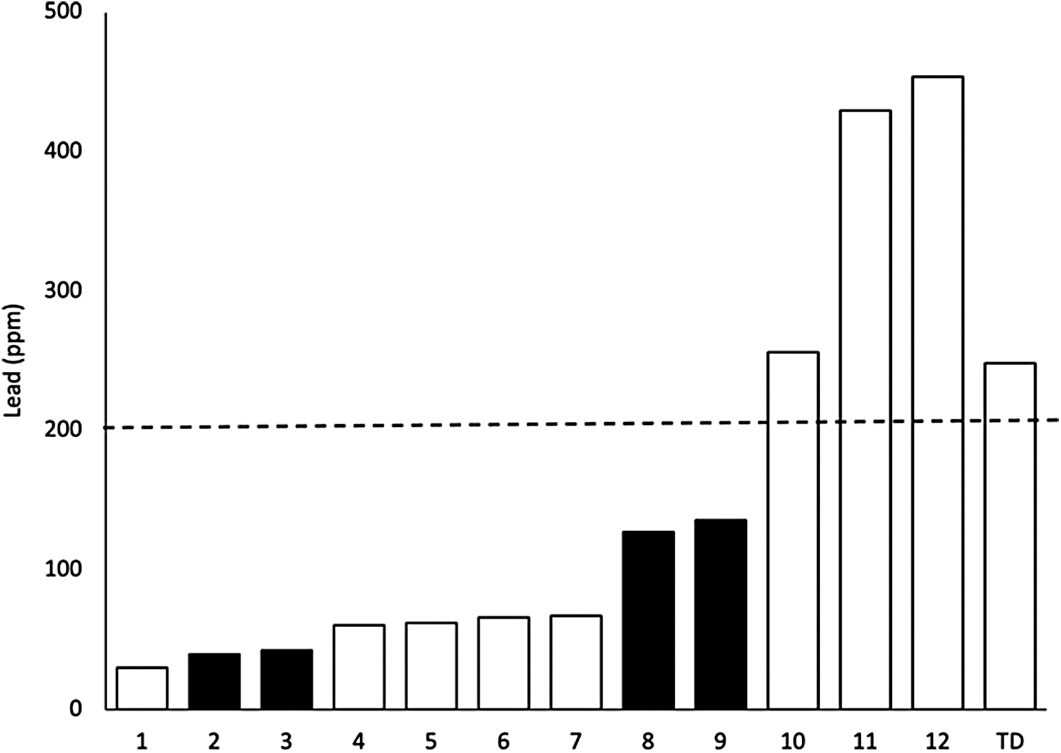
Average lead concentrations (arithmetic means) measured at 12 House of Knowledge sites and the average of 10 teardown sites. Note that 200 ppm is the safe gardening limit. 10 Sites with “high” average soil organic carbon concentrations (i.e., >5% by weight) are shown in solid black. Sites with low average soil organic carbon are shown in white.
Spatial evaluation across project years
Spatial analyses of housing vacancy density, median home values, and tax delinquency by HOLC Zones are presented in Table 3 and show that all variables followed the desirability rank order of HOLC Zones (A<B<C<D), with the exception of vacancies (B<A<C<D). Vacancies occurred more than six times as frequently in redlined (D) zones than in A and B zones. Similarly, median home sale values in C and D zones were four and five times lower, respectively, than the A zone. Likewise, tax delinquencies per square mile more than doubled from A to B and from B to C zones and increased by 18% from C to D.
Exploration of Springfield, Ohio Housing Variables by Home Owners' Loan Corporation Zone
2017–2018 data obtained from Housing In The Champion City: Comprehensive Housing Analysis For Springfield, OH.
HOLC, Home Owners' Loan Corporation.
All 567 soil samples analyzed between 2013 and 2020 are mapped over HOLC Zones in Springfield, Ohio (Fig. 2). Nearly one third were above recommended safe gardening limits of 200 ppm. This value is used in citizen science and garden research efforts and frequently compared with Environmental Protection Agency (EPA) safe gardening (400 ppm) and bare soil play area recommendations (1200 ppm).10,17 Samples that were collected within HOLC boundaries (n = 396) are compared in Figure 3. Median concentrations of lead were lowest in A and B zones at 80 ppm and 118 ppm, respectively. However, median D zone values were not significantly higher than the B zone at 121 ppm. Although the C zone had the highest median value (151 ppm), no detailed statistics have yet been performed due to sampling bias heavily favoring the C zone, which was sampled more than five times as frequently as any other zone. This sampling bias stems from the many community gardens and other land use projects of interest that were within the south-central portion of Springfield. Across housing and soil variables, it is clear that there are overlapping housing and environmental harms disproportionately impacting C and D zones in the Springfield, Ohio community, where low-income black families are most concentrated.
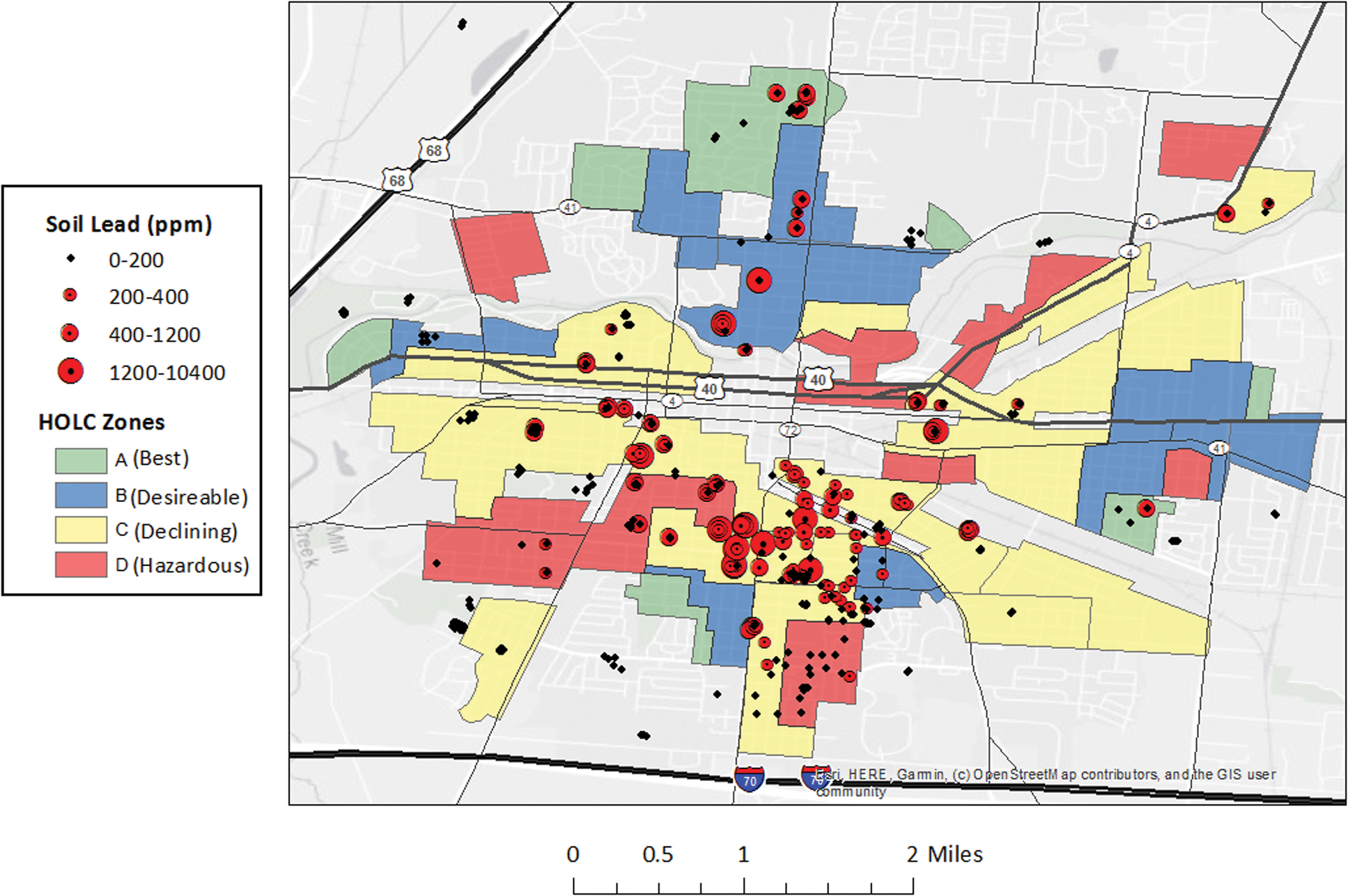
Soil lead concentrations in Springfield, Ohio overlaying HOLC Zones. Concentrations <200 ppm are considered safe gardening. 10 Concentrations between 400 and 1200 ppm are above EPA safe gardening recommendations and below safe bare soil play area recommendations. Concentrations >1200 ppm are above EPA bare soil play area recommendations. EPA, Environmental Protection Agency; HOLC, Home Owners' Loan Corporation. Color images are available online.
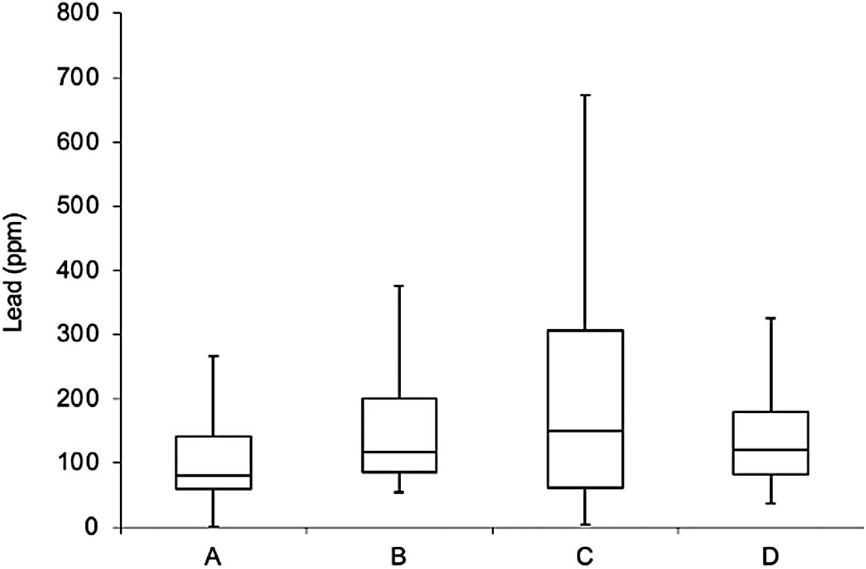
Boxplot showing the lower quartile (Q1), median value, and upper quartile (Q3) of soil lead concentrations in Springfield, Ohio soils by HOLC zone. Whiskers are set at 1.5 times below and above Q1 and Q3. The number of samples for each zone were: A-Best (n = 35), B-Desirable (n = 30), C-Declining (n = 281), and D-Hazardous (n = 50).
DISCUSSION
In addition to thinking about what these results mean for Springfield, there is a need to work across sites to influence policy. In Indianapolis a citizen science effort revealed that the majority of samples were above safe gardening limits, which was more than in Springfield, and highlights pervasiveness. 10 There is also a need to move more research from characterization to translation. Structural racism and the sustained harms to black and brown communities call for sustained and transformative work. Coproduction and boundary spanning provide a strategy to promote the immediate interests of frontline communities and to also contribute to ongoing capacity building and decision making. 19 , 20 Sustained engagement and building a spatial understanding through time deepens generational knowledge and improves discussions with community decision making and policy development beyond single garden efforts. 11 Until the local-to-national planning and policy responses advance environmental justice, there is a need to build community advocacy for policy change addressing many intertwined challenges. 10
Undergraduate scientists can be part of this capacity building, as demonstrated by this study. More broadly, whether coproduction is embedded into a course, or more widely adopted by scientists, research to design and test models for coproduction might explore attitudinal shifts surrounding racism, community, and ethical practices. The learning that occurs through coproduction informs the advancement of equity and justice and understanding this learning should be an area of research investment to improve science and support community desired change. Identifying and testing infrastructure to support projects is also a critical need. In this project, ongoing data collection and a website provided students with history, context, and connection to larger work, which promotes deep and generational shifts in learning. 21 , 22 Both technical and social mechanisms support the flows of information needed for project capacity building that spans multiple scales and levels (e.g., course to community and college to career) and cohorts (e.g., class to class). 19
CONCLUSION
Creating an inclusive ecosystem for cocreation and learning is a vital part of reversing systemic challenges. 20 Designing for coproduction and boundary spanning ensures learning across audiences, and maintains a focus on informing short- and long-term structural change20, 23 , 24 More research is needed on how to educate science students as agents of critical change. This study illustrates that there are opportunities to incorporate systems interactions and positive feedbacks into courses that provide students with the insights they need to move from isolated problem-solving to working for structural change.23,24, 25 Future research might also explore how courses that embed the skills and habits of knowledge coproduction shift learning and attitudes needed for environmental justice. Although this course embedded an experiential project, many of the skills and habits of this study might be incorporated into large earth and environmental science courses, including systems thinking, context and place-based learning, analyzing data in the context of structural racism, learning across knowledge boundaries (e.g., disciplines and cultures), and reflecting on case studies on the leadership of frontline communities that has advanced environmental justice.
Footnotes
ACKNOWLEDGMENTS
We thank the Wittenberg Environmental Science Program and The Conscious Connect for supporting this collaboration. We thank the many student, faculty, health, and community partners involved in this project and committed to engaging for change. Special thanks to those at the Springfield Promise Neighborhood and the Clark County Combined Health District who informed early work. Thanks also to Dr. Jennifer Latimer at Indiana State University for providing advice on navigating health and privacy issues as part of curriculum. Special thanks to Dr. John Ritter at Wittenberg University and the Metal Redlining Network for additional advice.
AUTHOR DISCLOSURE STATEMENT
We have no competing personal, financial, or funding conflicts of interest. Sarah Fortner has started a new position at the Science Education Resource Center (SERC), but this article does not pose any financial gain or loss to her, SERC, or her former employer, Wittenberg University. We also have no known personal relationship to anyone on the editorial board.
FUNDING INFORMATION
This research was funded by the Wittenberg University Environmental Science Program.
Supplementary Material
Please find the following supplemental material available below.
For Open Access articles published under a Creative Commons License, all supplemental material carries the same license as the article it is associated with.
For non-Open Access articles published, all supplemental material carries a non-exclusive license, and permission requests for re-use of supplemental material or any part of supplemental material shall be sent directly to the copyright owner as specified in the copyright notice associated with the article.