
Abstract
Abstract
The literature consistently shows associations of adverse cardiovascular and pulmonary outcomes with residential proximity to highways and major roadways. Air monitoring shows that traffic-related air pollutants (TRAP) are elevated within 200–400 meters of these roads. Community-level tactics for reducing exposure include the following: 1) high-efficiency particulate arrestance (HEPA) filtration; 2) appropriate air-intake locations; 3) sound proofing, insulation; 4) land-use buffers; 5) vegetation or wall barriers; 6) street-side trees, hedges and vegetation; 7) decking over highways; 8) urban design including placement of buildings; 9) garden and park locations; and 10) active-travel locations, including bicycling and walking paths. A multidisciplinary design charrette was held to test the feasibility of incorporating these tactics into near-highway housing and school developments that were in the planning stages. The resulting designs successfully utilized many of the protective tactics and also led to engagement with the designers and developers of the sites. There is a need to increase awareness of TRAP in terms of building design and urban planning.
Highway Proximity and Health
C
spend time in locations adjacent to busy roadways are more highly exposed to these pollutants.
Many studies have looked at where people live relative to major roadways and investigated whether closer proximity puts them at greater risk of adverse health outcomes. These “proximity studies” have consistently found that living closer to heavy traffic is associated with childhood asthma and reduced lung function,4,5 cardiovascular health and mortality,6,7 biomarkers of cardiovascular health, 8 and development of autism.9,10
We have been conducting community-based participatory research projects under the umbrella of the Community Assessment of Freeway Exposure and Health (CAFEH; <
In CAFEH, we monitored UFP in both near highway (<400 meters from highways) and urban background (>1 kilometer from highways) neighborhoods 20 and collected blood biomarker samples and lifestyle information from participants living in these locations. Resulting data were used to build land use regression models of UFP for the study areas. 21 These models predict hourly UFP levels at participants' residences for every hour for a year. Subsequently, we modified participant exposure by their time activity patterns and use of air conditioning. The resulting individualized exposures were used to test associations with blood biomarkers of inflammation and coagulation, which are predictors of cardiovascular disease risk. We have not published our main findings for association of UFP with the biomarkers and cannot report them here.
Environmental Justice
TRAP is an environmental justice issue because low-income and minority populations are disproportionately concentrated near high traffic volume roadways. A U.S.-wide study that linked National Health and Nutrition Examination Survey data to the National Highway Planning Network found that non-Hispanic blacks, Mexican Americans, and people living just above or below the poverty line were more likely to have higher TRAP exposure. 22 Two other studies recently conducted similar investigations of traffic exposure in the U.S. Both studies had similar findings. The first used census track level data and found that residential location of non-Hispanic blacks and Hispanics had positive Spearman correlation coefficients with road density. They also found a similar association for poverty. 23 The second study analyzed national data at a finer grain, using census blocks. This study also found that being non-Hispanic black, Hispanic, and low-income were associated with higher traffic volume and density. They also found that greater racial and income disparity were associated with increased traffic density. 24
Principles for Reducing or Avoiding UFP Exposure
Development of protective tactics for near-highway locations requires knowledge of atmospheric processes and TRAP emission rates. It is important to note that UFP concentrations change rapidly in time and space, which makes understanding exposure complex. However, because highway traffic patterns and UFP emission rates are predictable, we can build fairly reliable models to predict UFP concentrations at different locations and times.25,26 General principles for reducing or avoiding exposure should consider: 1) wind direction; 2) wind speed; 3) distance from busy roadways; 4) time of day; and 5) time of year. For example, based on the CAFEH study we found that the highest UFP concentrations occurred in Somerville within 0–50 meters of Interstate 93 (I-93) with distance-decay gradients varying depending on traffic and meteorology. 27
The annual median particle number concentration (PNC, a proxy for UFP) 0–50 meters from I-93 was two-fold higher compared to the background area (>1 kilometer from I-93). PNC was generally highest in winter and lowest in summer and fall, higher on weekdays compared to weekends, and higher during morning rush hour compared to later in the day. For winds out of the southwest and northwest, PN concentrations were elevated on the northeast side of I-93 relative to the southwest side, and when winds were out of the northeast the opposite occurred, indicating that I-93 is the dominant source of PNC to neighborhoods immediately downwind of the highway. PNC was also greatly impacted by wind speed: median PN concentrations were highest for calm winds (<0.3 meters per second) and lowest for wind speeds >1.6 meters per second.
Tactics for Reducing Community Exposure
Evidence for efficacy of different tactics to reduce near-highway communities' TRAP exposure was reviewed. These tactics derive from empirical research and are intended for consideration in building and community design. They comprise methods to reduce TRAP generation, prevent pollution from reaching locations people frequent, and move people away from pollution. We searched for studies specifically measuring air pollutant concentration differences as a result of each tactic in PubMed and in the urban planning and environmental science literature. Although many papers claim that these tactics reduce TRAP exposure and improve health, there were limited measurements demonstrating these effects. Therefore, effectiveness of the different tactics based on the literature was classified as good (>40% potential reduction), moderate (<40% potential reduction), or inconclusive (insufficient evidence) for both on-site and off-site tactics (Table 1).
Land use buffers can often be used to separate sensitive land uses (e.g., residences, schools) from traffic and other sources of air pollution. TRAP exposure zones with concentrations 40% to 90% higher than concentrations in urban backgrounds extend about 50 meters to 1,500 meters from highways and major roads, with most pollutants decreasing to background levels within 300 meters to 500 meters and at shorter distances upwind than downwind.28,29,30,31,32
Siting parks requires consideration of competing factors. Although poor siting (e.g., in TRAP exposure zones) can expose children to air pollution, parks also provide benefits and services that might outweigh pollutant health risks, especially for communities without alternative park space.33,34,35
Reducing pollution entry into buildings is the most effective on-site method to reduce TRAP exposure indoors. Multiple guidelines support moving air inlets to locations with cleaner air.36,37,38 Research suggests placing air intakes on rooftops or on sides of buildings that do not face roads can decrease pollutant concentrations indoors.39,40 Infiltration of TRAP can also be reduced by tightening buildings, frequently achieved using soundproofing or energy efficiency measures.41,42,43,44,45
Filtration is an effective method for improving indoor air quality. In the U.S., filters are rated based on the minimum efficiency reporting value (MERV, higher is more efficient) for particles in the 0.3–1 μm, 1–3 μm, and 3–10 μm size ranges.46,47,48 Although minimum efficiencies are not reported for UFP, pilot studies have shown that at least some high-MERV filters can remove UFP.49,50 Challenges with filtration include improper filter replacement and long term maintenance. 51
Moderate effectiveness can also be achieved through urban design. For example, avoiding wind flow through open areas below raised highways or orienting street canyons so that wind flows through them instead of stagnating could reduce pollutant concentrations by one third to one half. 52,53,54,55 In addition, garages and street parking could be distributed so as to decrease driving or low emissions zones could substitute some of the vehicle fleet with electric vehicles.56,57
Urban vegetation including green roofs or walls can also decrease air pollution slightly, particularly in highly polluted cities (e.g., Mexico City), through deposition on leaf surfaces and reduced need for air conditioning due to the cooling effect provided by the soil layer and building shade.58,59,60,61,62 Vegetation along the side of a busy road can reduce air pollution behind the vegetative barrier by less than 40%, although results vary greatly by wind direction and study.63,64 When planning urban vegetation, it is important to note that vegetation in street canyons can increase pollutant concentrations by as much as 33% due to decreasing wind flow and ventilation.65,66,67,68,69 Off-site, solid or vegetative noise barriers along highways can decrease the amount of air pollution reaching neighborhoods.70,71 Factors such as the effects of barrier height and road width require further study.72,73 The limited evidence for vegetative barriers suggests that dense vegetation performs similarly to a solid barrier by both blocking and filtering air pollution, with effectiveness depending on wind direction and whether the roadside trees are deciduous or evergreen.74,75,76
Bicycle or other active travel lanes can be separated from traffic to reduce TRAP exposure for people breathing heavily during exercise.77,78,79 Larger-scale projects like capping highways with decking has been shown to reduce concentrations near one major project.80,81,82 However, elevated air pollution levels have been measured in highway tunnels and near vents/exits to decked areas, leading to potentially higher exposures for commuters and people living near vents/exits.83,84,85,86
There is increased interest in urban agriculture to improve access to fresh, healthy, affordable food and reduce transportation costs while lowering carbon emissions, 87 but it has led to questions of how garden location affects exposure. In fact, some vegetables can accumulate pollutants from the air, resulting in a dietary exposure pathway.88,89
Charrette Methods
In May 2014, the CAFEH team used lessons from their research to organize a charrette that brought together environmental scientists, health researchers, architects, planners, community members, and designers in a creative problem-solving session focused on near-highway projects in Somerville and Boston Chinatown. 90
Somerville case example
The City of Somerville, MA, just north of Boston, is highly burdened with TRAP. The city is the most densely populated in New England with 78,000 residents living within 11.6 km2. The city is crossed by I-93, Boston's main North-South highway (about 170,000 vehicles/day); 91 Rt. 28, (about 38,000 vehicles/day); 92 Route 38 (about 34,000 vehicles/day); 93 and other high volume roadways. This results in high UFP levels in residential areas near the roadways. 94 The Somerville population is economically and ethnically diverse with many low income and immigrant residents living near major roadways. Demand for housing and commercial space combined with little developable land has resulted in pressure to develop near highways.
A vacant site in the city was selected to be a test case in our charrette to consider pollutant exposure mitigation strategies. The site is located <200 meters from both Interstate 93 (I-93) and McGrath Highway (Rt. 28), and is next to a Stop and Shop supermarket. Surrounding the site is a small abandoned park and a neighborhood of two and three family homes. The nearby area includes several commercial buildings and Foss Park, the largest park in Somerville (Figure 1). The site is zoned for commercial use, but a residential developer aims to amend the zoning to allow residential development. The vacant parcel, located near so many TRAP sources, is similar to much of the remaining developable land in the city.
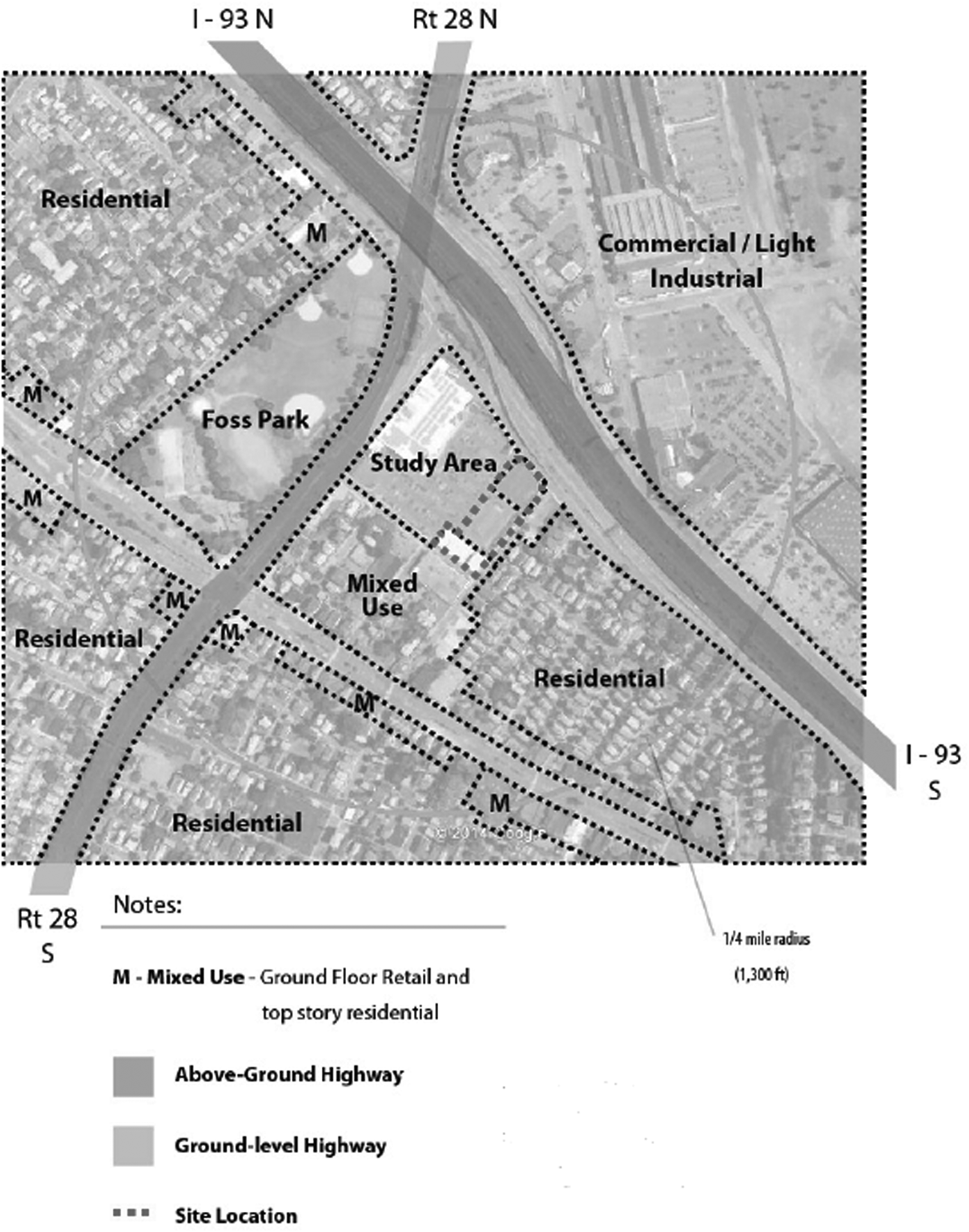
The Cross Street East site in Somerville. The site is located near both I-93 and Route 28. Credit: D. Brugge, J. Durant, A. Patton, J. Newman, and W. Zamore. Improving Health in Communities Near Highways: Design Ideas from a Charrette. Community Assessment of Freeway Exposure and Health. Nov, 2014. Available at: <
Concepts that emerged in the charrette ranged from design elements for the proposed housing to neighborhood-wide plans. Multiple types of barriers were considered. There are currently no sound walls along I-93 or McGrath near the site. Rather than traditional walls, charrette participants opted for more functional barriers such as minimally occupied structures including parking garages and commercial buildings (with high efficiency filtration) situated between the highway and the proposed new housing. Participants also considered vegetation buffers to be planted in the abandoned playground next to I-93. The goal was to reserve areas farther from the highway for more sensitive, residential uses, while also blocking flow of pollutants into residential areas (Figure 2). 95
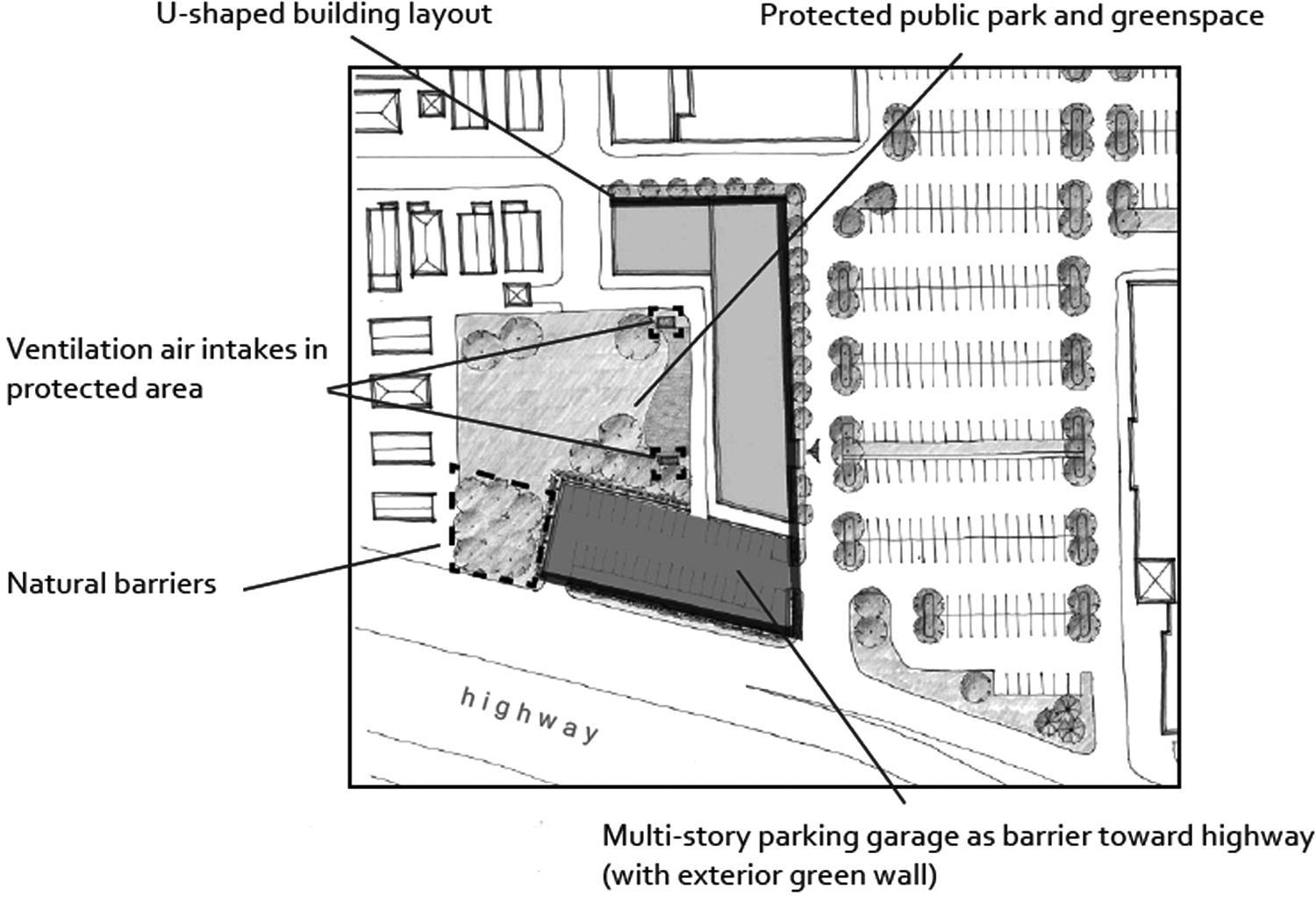
A design to reduce exposure to traffic-related air pollutants (TRAP) at the site in Somerville. Credit: D. Brugge, J. Durant, A. Patton, J. Newman, and W. Zamore. Improving Health in Communities Near Highways: Design Ideas from a Charrette. Community Assessment of Freeway Exposure and Health. Nov, 2014. Available at: <
Concepts designed to reduce exposure at the nearby and heavily utilized Foss Park included creating earthen berms around the edges and a shell performance stage as functional barriers. In addition, participants recommended siting more active park elements, such as sports fields, farthest from the highways. While the focus of the charrette was on new development or redevelopment, addressing the pollution exposure of current residents was also considered. One recommendation was to provide residents near the highway with weatherization and filtering options, potentially through a city loan program.
Following the charrette, our work in Somerville with respect to this site has continued. We presented some of the charrette ideas to developers and are exploring ways to enhance the air filtration systems they propose to use in the housing, should it be approved for construction.
Boston Chinatown case example
Boston Chinatown is an historic neighborhood near the heart of downtown that lies at the junction of the Massachusetts Turnpike (I-90) and the I-93 expressway; most of the community's housing lies within 400 meters of the highway. Its surface streets are major access points to and from the highways. Chinatown is also Boston's densest neighborhood, with only 5.1% tree canopy coverage, compared to 28% for the city overall.
On the east side of Boston Chinatown lies a 20-acre tangle of highway ramps and empty land, owned by the Massachusetts Department of Transportation and designated as an important area for economic development. It was labelled the “Chinatown Gateway Special Study Area” in the 1990s. In 2013, as luxury downtown development made available parcels scarcer and even more valuable, Boston's outgoing mayor proposed to build a new $261 million two-school facility for the Josiah Quincy Upper School and the Boston Arts Academy on one of the Chinatown Gateway sites known as Parcel 25. The project would place more than one thousand public school students into a school that straddles an I-93 on-ramp and tunnel exit (Figure 3). Despite vocal concerns about the children's safety and health, the community has been largely supportive of the project, with no other suitable development location available in Chinatown.
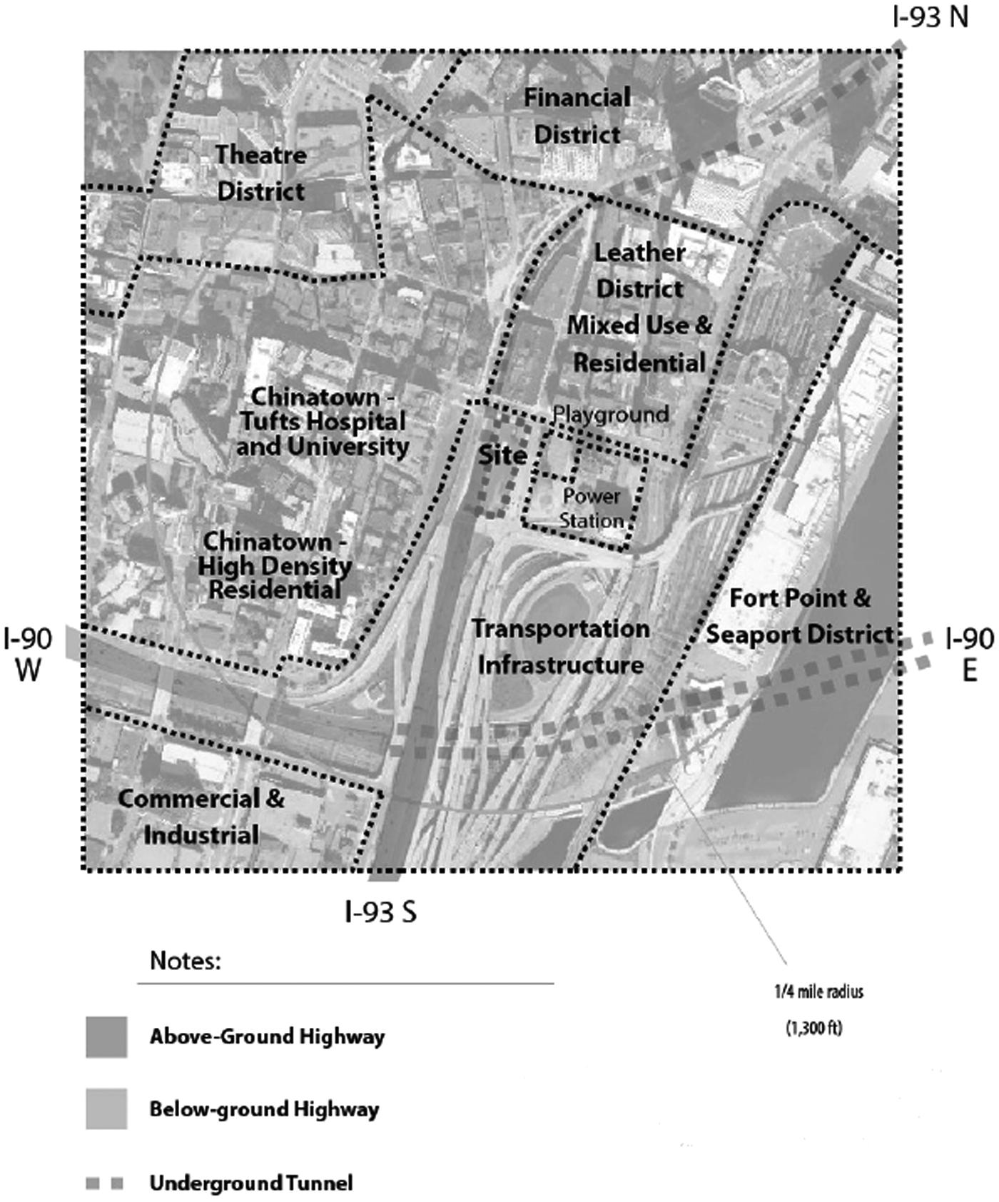
The Parcel 25 site in Chinatown. The site is located directly above I-93 at a tunnel exit. Credit: D. Brugge, J. Durant, A. Patton, J. Newman, and W. Zamore. Improving Health in Communities Near Highways: Design Ideas from a Charrette. Community Assessment of Freeway Exposure and Health. Nov, 2014. Available at: <
The charrette produced a host of mitigation ideas. One of the central concepts was to incorporate high-quality air filtration into the heating, ventilating, and air conditioning (HVAC) system of the school, paying attention to the siting of air intake units as far from the highways as possible. Other ideas included physical or vegetative barriers between the highway and the building and a large atrium with filtered air and plantings within the building interior (Figure 4). A broader recommendation was to call upon the state Department of Transportation to deck over the highways and provide large-scale air filtering of tunnel exhaust. Chinatown community members expressed that mitigation was both an environmental justice issue and a form of reparations to a community that was destroyed to make way for the highways over fifty years ago.
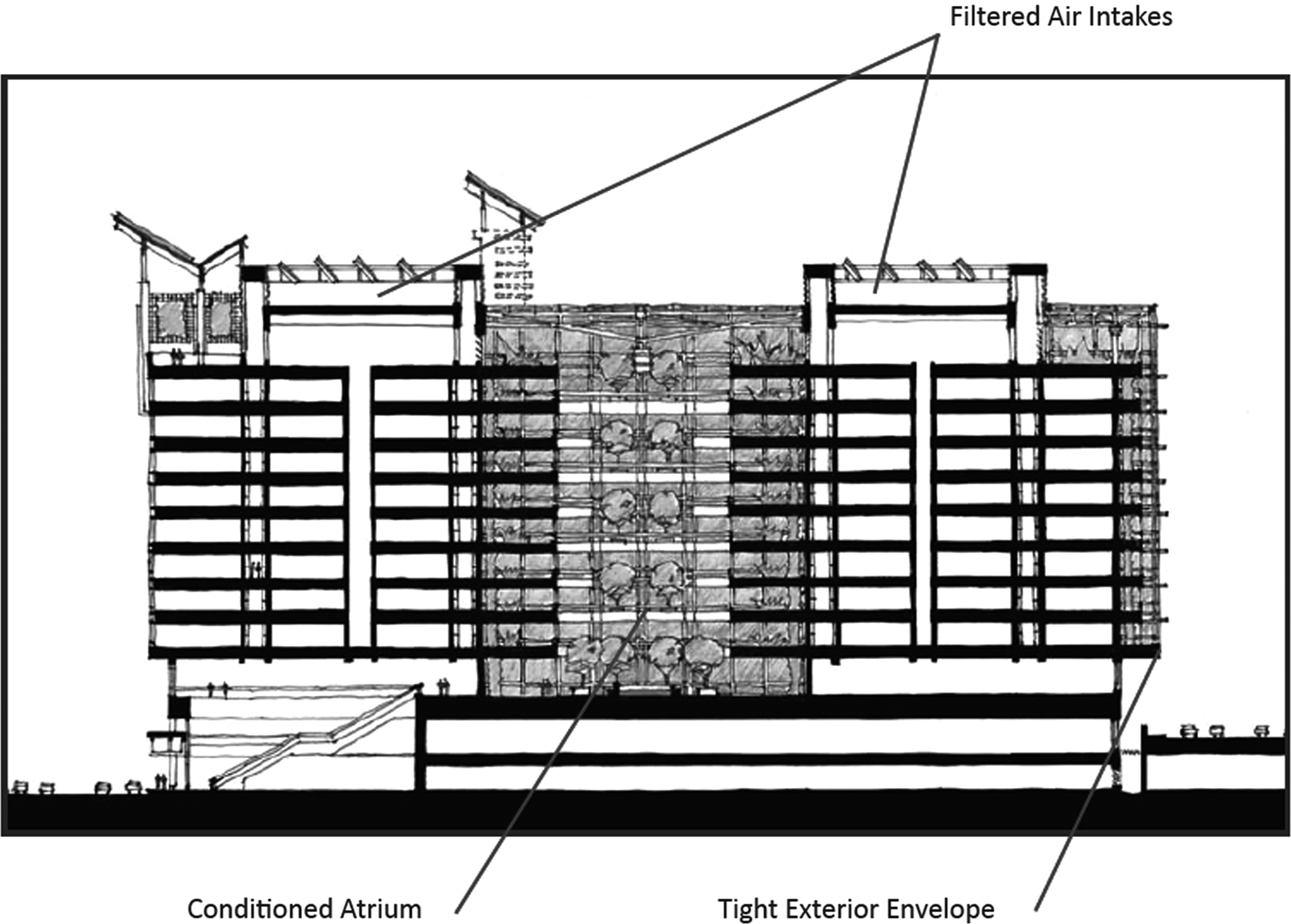
A proposed building design for the Chinatown site with two enclosed heating, ventilating, and air conditioning (HVAC) zones, joined in the middle by a plant-filled atrium Credit: D. Brugge, J. Durant, A. Patton, J. Newman, and W. Zamore. Improving Health in Communities Near Highways: Design Ideas from a Charrette. Community Assessment of Freeway Exposure and Health. Nov, 2014. Available at: <
Post-charrette, the architectural team for the school project altered its building design to relocate air intake units on the rooftop as far from traffic pollution sources as possible, combined with 100% replacement air, and incorporated high-MERV air filters into its HVAC system design. Since then, plans for the school have been put on hold by Boston's new mayor, but one of the project's architects has become a vocal advocate of this type of healthy building design and will hopefully bring this knowledge into future near-highway schools.
Municipal strategies
Municipalities have a range of tools at their disposal for enhancing the health and well-being of residents living near highways. While fine particulate matter is regulated at both the federal and state levels, the lack of federal and state standards on UFP has hampered municipal efforts to mitigate the negative health effects of UFP exposure. Since TRAP concentrations are highly variable and challenging to predict, many municipal responses have included air quality testing requirements. Monitoring is also crucial to further research on the health impacts from UFP. 96
The most effective regulatory model, either through zoning or a standalone law, is to restrict what can be built within a defined buffer zone around high pollution roadways. For example, regulation might include restrictions on the location of residences, schools, and active parkland. Non-restricted building types could be permitted within a buffer zone, subject to indoor air quality standards. California restricts siting schools within 500 feet of urban highways (more than 100,000 vehicles per day [vpd]) and rural highways (more than 50,000 vpd) unless prescribed conditions are met. 97 This restriction, while not codified by federal standards, sets the stage for municipalities to define high pollution exposure zones and land use guidelines for near highway locations. However, in many urban settings this is not sufficient as urban building densities, including schools and housing, around highways and other high-traffic roadways are already established.
Communities may be able to require protective air filtration for residential or school buildings within a buffer zone of highly traveled roadways through ordinances or conditions put on new developments. In California, the community of Jurupa Valley focused on very specific pollution conditions and forced a legal settlement with companies and municipalities that mandates and pays for filtration in residences and schools within a specified buffer zone. 98 New construction of multi-family affordable housing near highways may offer an opportunity for other municipalities to take similar measures.
Conclusion
The growth of interest in “green buildings” and “healthy homes” has mostly focused on addressing indoor sources of air pollution. We show here that there is an equally important need to consider and prevent exposure to ambient pollutants that infiltrate into homes and schools. While there is a need for more research on the tactics described in this article, we feel that it is possible, with the evidence available now, to better protect people from TRAP emanating from high traffic roadways.
Footnotes
Acknowledgments
We thank the Kresge Foundation for their support of the work reported here. The original research from CAFEH was funded by a National Institute of Environmental Health Sciences (NIEHS) grant (ES015462), the Jonathan M. Tisch College of Citizenship and Public Service (through the Tufts Community Research Center), U.S. Environmental Protection Agency (EPA) (FP-917203, FP-917349), and a P.E.O. Scholar award. Dr. Patton was partially supported by an NIEHS training grant in exposure science to Rutgers University (T32 ES198543). Participants in the charrette, besides the authors, were: David Arond, Brad Bellows, Jeremy Bowman, Richard Chang, Damon Chaplin, Lawrence Cheng, Meera Deean, Martine Dion, Shauna Gillies-Smith, Chin Lin, George Proakis, Denise Provost, Matt Simon, Josh Safdie, David Spillane, Dee Spiro, Noèmie Sportiche, Anne Tate, Terry Yin, Felix Zemel, Michael Ginieres, John Gravelin, Sherry Hou, Peter James, Sae Kim, Jon Levy, Dana Lewinter, Angie Liou, and Yi Qi Lu.
Author Disclosure Statement
Dr. Brugge has received funding from: International Physicians for the Prevention of Nuclear War to participate in a 2013 Uranium Mining Conference in Tanzania, Better World Fund to participate in a 2014 Health Effects of Fine Particles from Vehicle Emissions Workshop, and