
Abstract
In the late eighteenth to early twentieth centuries Qing officials in China periodically instructed their Mongolian subordinates to make maps of the regions they governed. The Qing were aiming thereby to gain information about the Empire, but the Mongols had other concerns. This article focuses on Mongolian map-making practice and argues that it differed from that prevalent at the time in both China and Russia. Concerned less with conveying practical information than with locating the domain in a cosmological understanding of the world, the Mongol maps were holistic. They were also both ‘participatory’, involving several different actors in their compilation, and ‘relational’, concerned to demonstrate the stance of the map-making subject in relation to the map's receiver (the office of the Lifanyuan and ultimately, the Qing Emperor).
Mongolian maps made in the context of Qing imperial projects of governance were surprisingly different, in concepts, techniques and visual imagery, from Chinese maps of the same period. The literature devoted to East Asian cartography has been dominated by the Chinese examples. This paper, which focuses on the Mongol case, attempts to steer a fresh path not only in documenting culturally different practices but also in the approach taken to cartography as an object of study.
The major theme discussed in earlier work was the one that preoccupied Needham, the invention and development of precise cartographic techniques, along with consideration of the influence of European scientific methods. The concern was with ‘knowledge’ as the core of cartographic activity and with the epistemic-apodictic nature of mapping. Later studies turned to the cultural factors that should be taken into account (Yee 1994) and the political and economic knowledge-gathering aspects of the Qing endeavour (Perdue 1998; Millward 1999). Broadly, maps were to be understood as instrumental-political in character. This article does not ignore either of these perspectives but argues for the need to invoke a third approach, one that is founded on the implications of the practices of map-making. It will be suggested here that Mongol map-making was both ‘participatory’ (Crampton 2009), involving several diverse kinds of actors, and ‘relational’, since maps were designed for particular recipients or readers. In the Mongol practice, the task of mapping – charting the contours and contents of a territorial surface – was of less concern than the creation of maps as a ‘placing’ of the subject, i.e. the domain and its people, in a cosmological vision of the world. The graphic techniques, the approaches taken to orientation, and the language of inscriptions and reports attached to maps reveal much about Mongolian spatial thinking.
To clarify further: the China-focused literature has paid relatively little attention to the implications of the fact that when the Qing government requested subject territories to create their own maps and supply them to the capital, this could not be done according to the cartographic practices known in metropolitan China. In distant regions such as most of the Mongolian lands, it was not just that neither the surveying equipment nor the trained specialists were available (Amelung 2007) but that the very geographical ideas held locally were different. The Mongols’ authorities were left to interpret the imperial instructions as best they could, using the personnel, techniques and language at their disposal. The results were extraordinarily varied, and they reflect a range of graphical traditions, cosmologies, and views on what it was important to depict that were specific to the Mongols. Much of the academic literature on Mongolian maps forms a separate body from the Chinese (Heissig 1944, 1961; Chagdarsurung [Shagdarsüren] 1976; Futaki 2005; Inoue 2014). This article, while recognizing the situation of the Mongols within the Qing Empire, seeks to avoid the suggestion that they can only be studied and understood as ‘other’ to their imperial masters. The attempt, rather, is to understand the ‘science’ involved in Mongol map-making. This does not refer to the adoption of sophisticated Chinese or European ideas and techniques, which in any case were unavailable to Mongols, but to the intellectual and practical activity involved in attempts to depict systematically their own understanding of distance, orientation, proportion, and scale in relation to the physical and social world. The argument is made that where map-making was concerned, the Mongols, while attempting sporadically to adhere to Qing cartographical instructions, in practice made use of their own intellectual resources in ways that simultaneously both conveyed their understanding of geography and cosmology in general and also created ‘messages’ of self-emplacement to the Qing authorities. In this sense, the maps have to be understood as relational documents, as ‘rhetorical maps’, to use the term proposed by Harley (1988) and Perdue (1998, 275), and as ‘performative’, as suggested by Crampton (2009). 1
In considering the science involved in Mongolian map-making, let me start with some issues raised by Gell's article ‘How to read a map: remarks on the practical logic of navigation’ (1985). The article was inter alia a critique of Hallpike's account of ‘primitive thinkers’, according to which such people are limited to ‘practical wayfinding’, which is informal, subjective, and based on habit and familiarity, as distinct from technologically advanced kinds of wayfinding, which involve the abstract representation of spatial relations (Gell 1985, 273). Gell rejects this contrast altogether and defends instead a version of the notion, put forward by many geographers, anthropologists, and cognitive scientists, of ‘mental maps’, i.e. stored information about a terrain, along with some inferential schemes for converting such models into practical decisions and actions. In this view, the mental map used by the experienced native is in one way not so very different from the artefactual map used by a stranger. The key point made by Gell is that in either case, we can only find our way around because we locate our bodies in relation to external coordinates that are unaffected as we move about, and it is only in relation to these coordinates that we hold beliefs about the other kind of location, that of places perceived as relative to our own position (1985, 279). 2 Therefore, he rejects the ‘behaviouristic’ notion he attributes to Hallpike and also to Bourdieu, that ‘practical’ space is ego-centric and defined only by coordinates that meet at the agent's own body. Both kinds of knowledge, Gell argued, are necessary in order to know where we are. 3
In general terms, the Mongolian manuscript maps discussed here 4 – i.e. those created by hand before the appearance of printed maps made according to versions of modern global standards – support Gell's argument. However, they do raise the question, more starkly than is apparent in Gell's article, of what it was that the mapmakers took as the external coordinates, i.e. the spatial relations that I shall call for short ‘cosmological’, in the sense that they do not change truth value according to place from which they are stated. If we think comparatively, it is apparent that the world has known many different schemata that can be thought of as universal in this cosmological way. Gell mentions, for example, the ‘star courses’ used by Pacific navigators and British Admiralty charts; these are very different from one another, but both have the ‘essential map-property’ of providing non-ego-centred spatial coordinates (1985, 284). One problem posed by Mongolian maps is that they had to negotiate between several such systems known to them, choosing one or another, or alternatively prioritizing one over the other on the same map, or even occasionally giving up on depicting external coordinates altogether – leaving them implicit and requiring the intuition of the map-reader. Another curious feature of many of the Mongolian maps is that ‘ego’ also often features inside the representation of a territorial space. This invisible ‘subjective’ agent appears either as the implicit locus of a ‘point of view’ from which elements of the representation appear or as an inscription in words written as ‘I’ or ‘we’ on the map. This paper will make the case that the presence of this ‘ego’ is not a result of deficient skill in abstract thinking as Hallpike would have it, nor is it primarily to do with wayfinding or practical knowledge. Rather, both of these features, the choice of coordinates and the subject-related features, appear as they do because Mongolian maps were made on behalf of particular princely authorities and addressed to a specific recipient, the Manchu emperor. The maps I will be discussing are not about knowing where we are but about stating where we are to an intended reader.
From the mid-eighteenth century until the early twentieth century, the Qing government in Beijing, on behalf of the emperor, ordered the rulers of their subject Mongolian territories to produce maps of their lands and submit them to the Lifanyuan, the Bureau responsible for administering these regions. In principle, these maps were to be regularly updated but in practice, the supply of maps was desultory and only spiked in the years immediately after an imperial edict. 5 The practice of submitting maps continued under the Chinese Republican and Mongolian socialist governments into the 1920s and 1930s. Almost all of the manuscript maps analysed here were of this kind, having the primary aim of reporting on the boundary, geographical components and situation of the administrative units called ‘Banners’ (M. qoshigu, khoshuu) in the period 1830s–1920s. As wayfinding by locals or strangers was not their purpose, they differ cardinally from the type of map discussed by Gell. So I should clarify that the reason I refer to Gell's paper is because the issues he raises about spatial location and direction are crucial in my view to understanding these Mongolian maps. We could say that all maps, from school atlases to the London Underground, are relational to some extent, i.e. made by some author(s) to be perused by some intended readership. The point has often been made that Qing authorities’ cartographic projects were set in train to produce maps for themselves, for their own bureaucracies and armies, in order to strengthen their rule over the provinces (Perdue 1998, 266). But the maps discussed here, though a response to the imperial order, were made by local Banner rulers and they, being distant from the capital, depicted location and direction from their own points of view (see Perdue 2003). In terms of power relations, these were maps produced not by masters for themselves, but by subjects for a higher authority. What is interesting and under-researched about these maps is how the Mongols’ cartographical devices (direction, coordinates, measurements, labelling, use of colour, etc.) usually considered merely indexical techniques of representing a physical array of objects were used in particular ways: to represent the character and value of the particular territory, to emplace the ruler in it, and sometimes to imply a certain independence of status vis-à-vis the recipient of the map (the Qing state).
The political conditions of production of Mongol maps
The Qing rulers, like those of earlier dynasties, made atlases and maps of their Empire, and being themselves of Manchu hunting/herding/farming stock were aware of the need to cultivate good relations with – and restrain – the potentially volatile nomadic Mongols. In military campaigns, Mongol allies could be an important resource. The Manchus therefore assigned Mongol groups to Banners from which a known number of reserve soldiers could be recruited when necessary. Most of these were to be governed by a single hereditary lord-ruler and ordinary herders were forbidden to stray outside the pastures of their Banner. The Banners were grouped into larger regions, known as Leagues, but since the Qing and later the Chinese Republic were anxious that the Mongols did not join together into unruly threatening conglomerations, the Leagues had little power and the Banners lords were in direct contact with the Imperial administration. This explains why the great majority of the extant maps are maps of individual Banners, floating free on the page, as it were, without extension into neighbouring territories. 6
Specific maps were requested by the Lifanyuan in order to provide proof of the borders of the Banners, a decision that was taken after the limits of each territory had been decided in principle. The Lifanyuan ordered both League and Banner boundaries to be marked by cairns of stones (M. obuga, oboo), using an earlier Mongol tradition of building oboos on the top of mountains. 7 If no cairns existed on the putative edges of the Banners, new ones were to be erected. The notional line between these cairns would constitute the boundary. In principle, the name of each boundary oboo was to be inscribed on the main rock (Chagdarsurung [Shagdarsüren] 1976, 365). However, cairns could be moved, or they might disintegrate into rocky heaps little different from the surrounding landscape. Thus, despite instructions to maintain the oboos, considerable doubt about the exact borders reigned well into the twentieth century, which was the cause of numerous disputes between neighbouring Banners. This is no doubt why Constant (2010) argues that the primary reason for the making of maps was to aid in resolving boundary conflicts.
However, a broader examination of Qing map-making policy, as well as examination of the maps, reveals that this cannot have been the only reason – certainly not in the longer historical run. The Kangxi emperor, engaged in the 1690s in military campaigns against the Zhunghar in the far west and having earlier negotiated with the Russians to fix a border in the north, was personally involved in establishing a reliable continent-wide geography and aligning this with geometry, meteorology, and astronomy. He was intensely engaged with the Jesuit missionary scholars who had brought knowledge of measurement of latitude and longitude to China. In this period, the emperor's broad political strategy as well as his own sheer intellectual interest was the main inspiration for map production. As Cams describes (2017, 31–35), the emperor used both European and Chinese cartographic practices to determine precisely the border between the Inner Mongolian lands and Qalqa / Khalkha (Outer Mongolia) (see further below). The ability to make maps for military purposes, ones that accurately reflected the great distances the emperor would lead his Qing armies against the Zhungars, was crucial at this time.
Subsequently, the purpose of ordering the creation of maps shifted. After the conquest of the western regions and border treaties with Russia, although the formerly paramount criterion, assurance of the personal loyalty of Mongolian nobility, did not disappear, the significance of knowledge about the territories themselves gradually grew. It became important to know the dimensions and resources in the administrative the units of the empire and to keep them stable and peaceful. Clarification of boundaries remained salient for governmental purposes. After a dispute over land, a general in the far western Mongolian domain was ordered in 1781 to erect oboos at the boundary with Qalqa/Khalkha and the officials were ordered to prepare maps. From this time onwards, inter-Banner boundaries too were increasingly officialised. Later, with increasing pressure from Russia, reinforced by the 1860 treaty which gave rights for Russian traders to work inside Qing territory, Chinese officials were sent out in 1867 to produce a gazetteer with appended maps of the Inner Mongolian Banners near the northern frontier.
8
However, even in these areas, as well as in the vast steppes beyond, it was the Mongol authorities who were required to produce maps. While many of their maps mark and name boundary oboos according to instructions, others, particularly in the west of Mongolia (Futaki 2005, 30–31), do not delineate a border of any kind; some are content with vague sketches of a mountain range or a river, and yet others depict the Banner as a ruled rectangular outline, when we know that no actual Banner had such a regular geometrical shape. It is evident that borders were not the main preoccupation of the Mongols (see Perdue 1998) (Illustrations 1a and 1b).
Altai-Urianghai 1912–1914; Horchin Left Banner, 1907; Horchin Right Banner, 1907.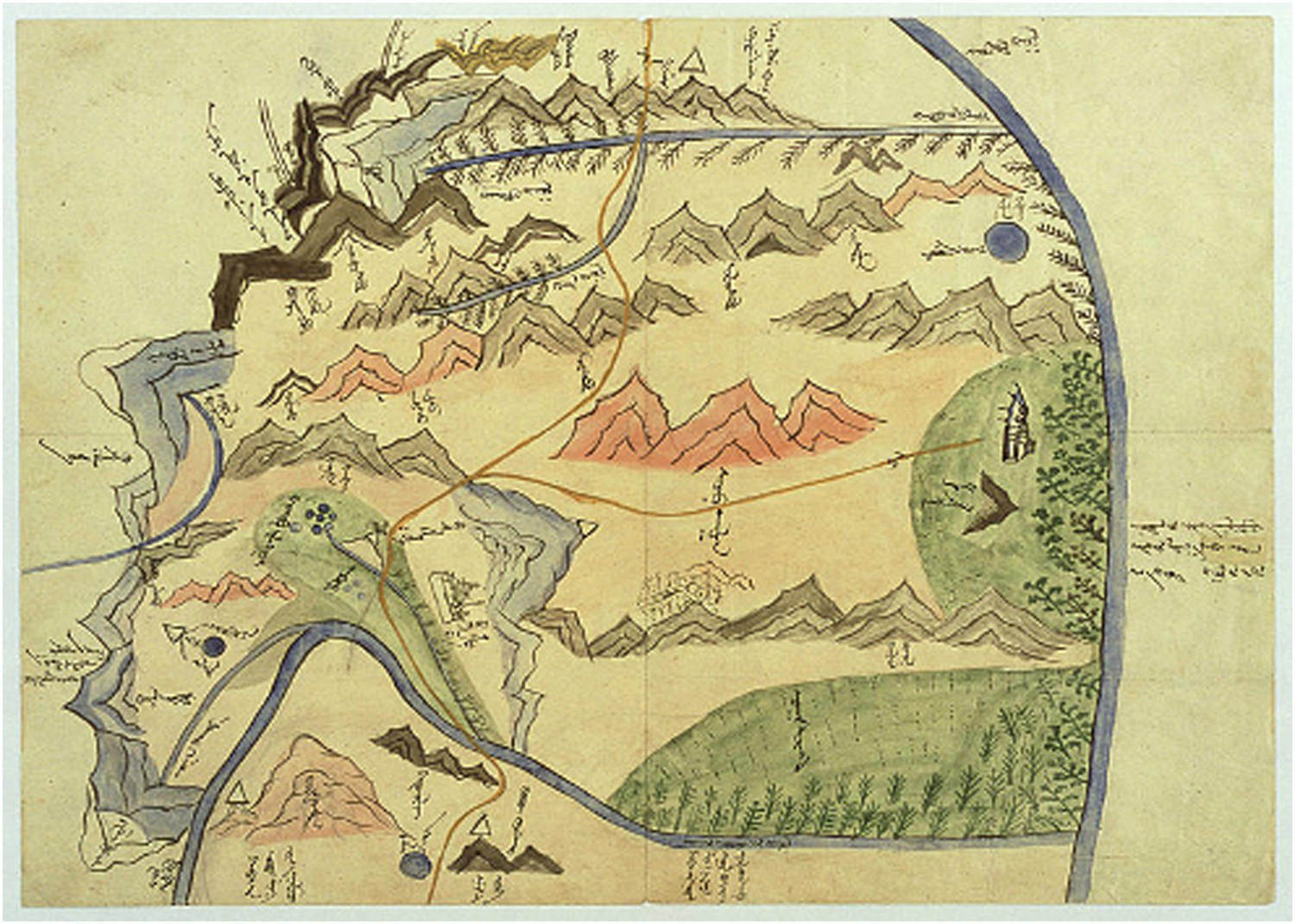
These Mongol mapmakers had other concerns. It is clear from the great visual variety of the drawings that they were not the standardized work of officials sent out from Beijing to map Mongol lands. Local artists/draughtsmen must have made the images with their own geographical concepts in mind. To begin to understand what these were, we need to think about how the maps were physically/graphically made, and to do this, we should first take a brief look at the visual languages of mapping available.
The Mongolian maps in the context of Chinese and Tibetan map-making
Little is known about the maps the early Mongols may have used (see footnote 3). During their thirteenth to fourteenth century conquests, they presumably came across the classic Islamic geographies and maps, and later in the seventeenth century, they may have encountered Russian maps (Waugh 2015, 70, 75–79). However, neither of these had a lasting influence. The maps that concern us here were created in the context of several other, different but overlapping, map-making cultures that existed in north and inner Asia during the late Qing. In this section, I look at Mongol practices in the context of Chinese and Tibetan traditions.
In China, despite the existence of mathematical paradigms for map-making since the third century (Li 2018), the use of grids to represent orientation and distance under Persian influence from the Mongol Yuan period (Kauz 2013, 161–162), and the introduction of European ideas of latitude, longitude, and Mercator projection by the eighteenth century, practical implementation of these methods was sporadic and had to contend both with inconsistencies between these techniques and with other non-mathematical traditions. 9 The Kangxi Emperor personally compared the Jesuits’ measures of latitude using Paris-made instruments with the standard distances in li (linear measurements taken with ropes and geometrically corrected) for the distance between Beijing and the Mongolian border town Guisui (now Hohhot). He was disturbed when experiments showed that the two methods did not coincide, concluded that the Chinese standards used in astronomical and cartographic practice were faulty, and in 1698 redefined the length of the li by imperial decree so that there were exactly 200 li in one degree of terrestrial latitude. Subsequently, other key measurements such as the smaller chi were redefined to conform (Cams 2017, 36–37). Many land surveys and maps, using the new li, were executed by mixed teams of European missionaries and Qing officials between 1708 and 1717. However, the astronomical and trigonometrical information provided by the Jesuits and its relation to cartography was for a long time restricted to a narrow court circle. And even if it had been made more widely available and well understood, there were not enough specialists trained in surveying nor enough instruments to cover major projects within China proper, let alone the outer tracts of the empire. Despite recognition of the need for maps, and by the mid-nineteenth century despite exposure to Western seaboard maps, the older traditions and the habit of copying earlier maps generally prevailed. A hybrid exception was the important map of the course of the Yellow River based on Western surveying techniques and delivered to the throne in 1890. It used projection, but the old (incompatible) grid system was employed on the same map. Probably for the first time in China, new ‘caterpillar’ symbols for depicting mountains appeared, i.e. a view from above rather than the conventional mark depicting mountains from the side; but there was no way of indicating elevation as on European maps (Amelung 2007, 696–698).
Meanwhile, map-making traditions that paid little attention to topographic accuracy continued to flourish. Hermeneutical flexibility was characteristic of Chinese cosmology, which enabled different schema and interpretative practices to coexist, including in cartography (Smith 2013). Incorporated in the multi-stranded Qing culture was a specifically Manchu imperial model. The ‘landscape enterprise’ of the Qianlong Emperor, as Philippe Forêt (2000, 5–11) calls it, planned the imperial residence of Chengde as a recreation in microcosm of the Buddhist realm of Mount Sumeru. To achieve this scheme, the Emperor used a combination of simple conventional maps, employing a vertical view, pictorial maps that depicted the sacred landscape from the side, looking upwards towards the sacred mountain, and coloured landscape paintings showing the alignment between temples, palaces, and pagodas.
Separate from this, an older Han Chinese non-mathematical tradition continued in the ‘descriptive paradigm’ of Wei Yuan (1794–1857). In one of his maps, Wei depicted the Qinghai (dark blue sea) as a nebulous spiral hovering an indeterminable distance above the Yellow River, with an explanation written on the page that ‘ … even today it does not have the buoyancy to support ships or even a goose feather. Only in bitter winter when the water freezes do Tibetan monks enter into it [walking across the frozen water onto the two islands in the lake] with food for half a year in order to sit and meditate there’ (Li 2018, 124). More generally, Wei's concern was with the geopolitical situation of China, the sea-borne threat of the English barbarians, and need for an alternative Chinese geography that represented a dynastic or diachronic greater China extending across Inner Asia, the historical depth being given by use of ancient names and descriptive explanatory texts (Li 2018, 141). Written inscriptions are integral to these maps. The same is true of many of the Mongolian maps – only the kind of text the Mongols added had a different, non-poetic, character, as we will see.
Mongolian mapmakers in the Banners must have known distantly about the Manchu and Chinese enterprises, but their immediate task was to conform to the edicts with the techniques and forms of knowledge they had to hand, which were based on both long-standing indigenous measurements of distance and on Tibetan Buddhist geographical teachings. In contrast to Chinese maps, which were increasingly printed by the nineteenth century, Mongol maps were hand-drawn, using a brush, Indian, or other black ink, and paint or pencils for colouring (Inoue 2014). 10 The Lifanyuan had issued instructions about the symbols to be used – how to draw the sign for a well, an oboo, a road, a mountain, and so forth (see list in Chagdarsurung [Shagdarsüren] 1976, 362–364). 11 In 1890 new regulations firmed up earlier standards for mapping area, including the traditional grid, in which each square representing 100 gazar (M. ‘land’, in principle equal to one square li) should be drawn as one Chinese cun (3.2 cm) on the map (Kamimura and Futaki 2005, 16). The grids were to be aligned with the cardinal directions; they did not refer to latitude/longitude. But these rules could hardly be followed as stipulated. A difficulty was working out how to use these measures and render them on a reasonably sized page when text also had to be fitted in; this meant that the Mongols – even when trying to comply – used different scales, such as 100 gazar to 2 cun. Many maps left out grids altogether. If the Mongol maps did include a grid – making a bow, as it were, to cartographic basics in the ancient as well as the modern Chinese fashion – they normally provided no information about what the squares were supposed to represent. Furthermore, the Mongol terms used for the three permitted units of distance had their own indigenous meanings, unrelated to the proposed Chinese equivalents: gazar was 500 double-steps taken by a man; the qubi (M. ‘share’) was a division of the gazar, and the alda was the distance between outstretched arms. 12 The accompanying texts in Mongol normally cited distances between boundary oboos in gazar, qubi and alda, but some used a variety of other indigenous measurements of distance such as the num (M. bow, length of a bowshot 13 ) or the örtege / örtöö (M. distance between post-relay stations, a fast day's ride, c. 30 km).
The örtege was a well-understood ‘abstract’ unit of measurement that could be used irrespective of the mode of transport. As recently as the 1970s, Mongol herders with experience of ox-caravan travel retained mental maps of the distances and angles of march between a panoply of towns across Inner Asia calculated in örtege. They were able to sketch maps on paper of these mental images, marking, for example, the 23 örtege between town X and town Y as slashes on the line that represented the route (Humphrey 2020). The ability to do this involved arithmetical and geometrical thinking about geography that surely had a long history among the Mongols, as the post-relay was a highly developed and rather precisely developed technology in the Mongol Empire and the Yuan Dynasty. Daniel Waugh argues (2015, 73–74) that depicting itineraries was central to many Eurasian cultures of map-making. However, while we could speculate that depicting post-relay, along with military, routes may have been important in early Mongol times, tracing itineraries were not central to the late Qing-era maps, many of which do not indicate roads/routes of any kind. The reason for this absence may be that Mongols did not need roads for travel across the steppes and the relay routes used by officials were of less significance to them than other aspects of the landscape.
With the spread of Tibetan Buddhism in the sixteenth to seventeenth centuries, a different way of thinking about the world had come to pervade Mongolia. This is pertinent to our topic since Buddhist learning formed the educational background not only for the nobles who ordered the maps but also for the scribes who drew them. Akira points out (2005, 13) that the production of maps was a process of negotiation, and he suggests that three actors in the ‘power system’ were involved: the Emperor of China (or from 1911 the Bogd Khaan of independent Mongolia), the local ruling prince, and the herdsmen on the ground. Of these three, we can see the sovereign (emperor/Bogd Qagan) as the intended ultimate recipient, the local ruler as the authorizing agent for the map, and the herders as the people producing the information about places, distances, names, etc. that went into it. The mapmakers were a fourth set of participants. They were either monks trained in drawing/painting at one of the numerous monasteries that had been founded across Mongol lands, or former lamas, employed on a rotational basis as clerks at the Banner office. Many of their tasks were secular, such as translation of official documents, tax collection, and conduct of the ruler's correspondence, as well as local map-making. But their religious educational background is significant, since it included not only the techniques for painting the ideal landscapes in which deities presided but also the depiction of map-like cosmographical schema of Jambudvipa, the this-world continent of the four arranged symmetrically around Mount Sumeru and often represented by a mandala. Matthew Kapstein argues that although this Indic cosmology was notional and largely imaginary, during the eighteenth century, it became important for certain highly influential lama scholars to determine ‘just where on Jambudvipa are we?’, the title of his 2011 article. Sumpa Khenpo Yeshe Peljor, a learned monk who belonged culturally between Tibet and Mongolia, was concerned to align the plentifully available real geographical knowledge available to the Tibetans with his description of Jambudvipa. Thus, he included places as far away as Astrakhan, Moscow, and even Sweden in his textual account of the far reaches of the continent. However, what the Tibetans did not do, perhaps out of simple lack of interest, was to employ their skills in mathematics and geometry, used in calculating measurements for cosmic mandala diagrams, in making maps of the practical geography they read about in Sumpa Kenpo's works (Kapstein 2011, 341).
However, the transfer of religious painting techniques to quasi-realist landscapes did take place among both the Tibetans and the Mongols. Perhaps it would be more correct to say that there was a common visual language that could be used to depict, for example, human scenes illustrating moral precepts in thankas and in map-paintings of monasteries (Harley and Woodward 1994, 607–681). The best-known Mongol example is the work of Marzan Sharav (1868–1939), a former lama who more or less invented the Monggol zurag (Mongol painting style), adapting the techniques used in thankas and depictions of pilgrimage sites to secular themes. Sharav was called ‘Marzan’ (humourous) because his depiction of everyday life (people shearing sheep, defecating, fighting, having a feast, etc.) was unknown, shocking and funny at the time. The Monggol zurag style was two-dimensional, adopted variable perspectives as well as a ‘bird's eye’ view, used colour conventionally rather than realistically, and spread subjects across the canvas to the four corners – all characteristics also found in Mongol Banner maps. Indeed, Sharav's most famous painting, now known as ‘One day in Mongolia’, has been called a map (Tsultemin 2016) (Illustration 2).
B. ‘Marzan’ Sharav, 1912–1915. Mineral paint on cotton, 135 × 170 cm. Zanabazar Museum of Fine Arts, Ulaanbaatar, Mongolia.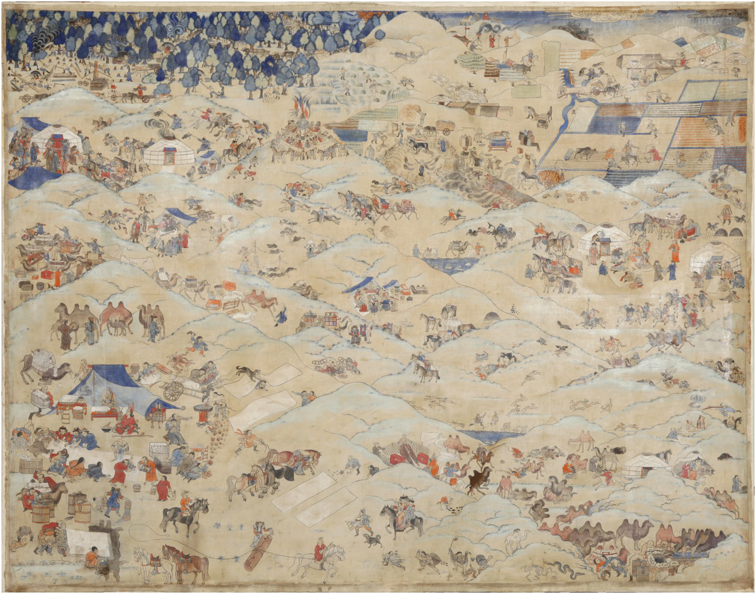
The painting was produced on the order of the Bogd Khaan, the new ruler of Mongolia shortly after the country had gained independence from China. Tsultemin argues (2016) that this work should be understood in relation to similar cartographic manifestations produced elsewhere in Asia when there was anxiety about the unity and survival of a nation. She cites Sankaran Krishna writing about cartography in postcolonial India, suspended in the space between ‘former colony’ and ‘not-yet-nation’:
By cartography I mean more than the technical and scientific mapping of the country. I use the term to refer to representational practices that in various ways have attempted to inscribe something called India and endow that entity with a content, a history, a meaning, and a trajectory. Under such a definition, cartography becomes nothing less than the social and political production of nationality itself. (Tsultemin 2016, 70)
The distribution of the subjects in ‘One Day’ is also relevant to the Banner maps I will shortly describe. Seemingly random, the painting was in fact carefully organized. This was done by distributing vignettes to the four corners and relating them visually by riders moving diagonally across the scene, and temporally by notional sequences (e.g. the bride leaves her home, the bride arrives at the groom's tent), and by making the heart of the painting the Buddhist teaching of the impermanence of life (the depiction of sexual intercourse, birth, and marriage arrayed around a central vignette of lamas conducting a funeral rite) (Tsultemin 2016, 80–82). Read this way, as a map, which Mongol viewers could easily follow from scene to scene, this representation was at the same time far more than a map – in that, at least implicitly, it situated these scenes of life in a cosmology, or perhaps it would be more correct to say, it allowed a cosmological reading of any part of it. Such a ‘placing’ as I shall now argue was also a feature of those very ‘secular’ artefacts, the Mongolian Banner maps.
Examples of Mongolian Banner maps
After a long discussion, a close analysis of two Mongol maps brings me back to the questions raised by Gell's article. I start with the issue of the rendering of ‘our own position’ by the author of the map. The first map (Illustration 3) is of the Üzümüchin Right Banner, Shilingol Inner Mongolia, 1890.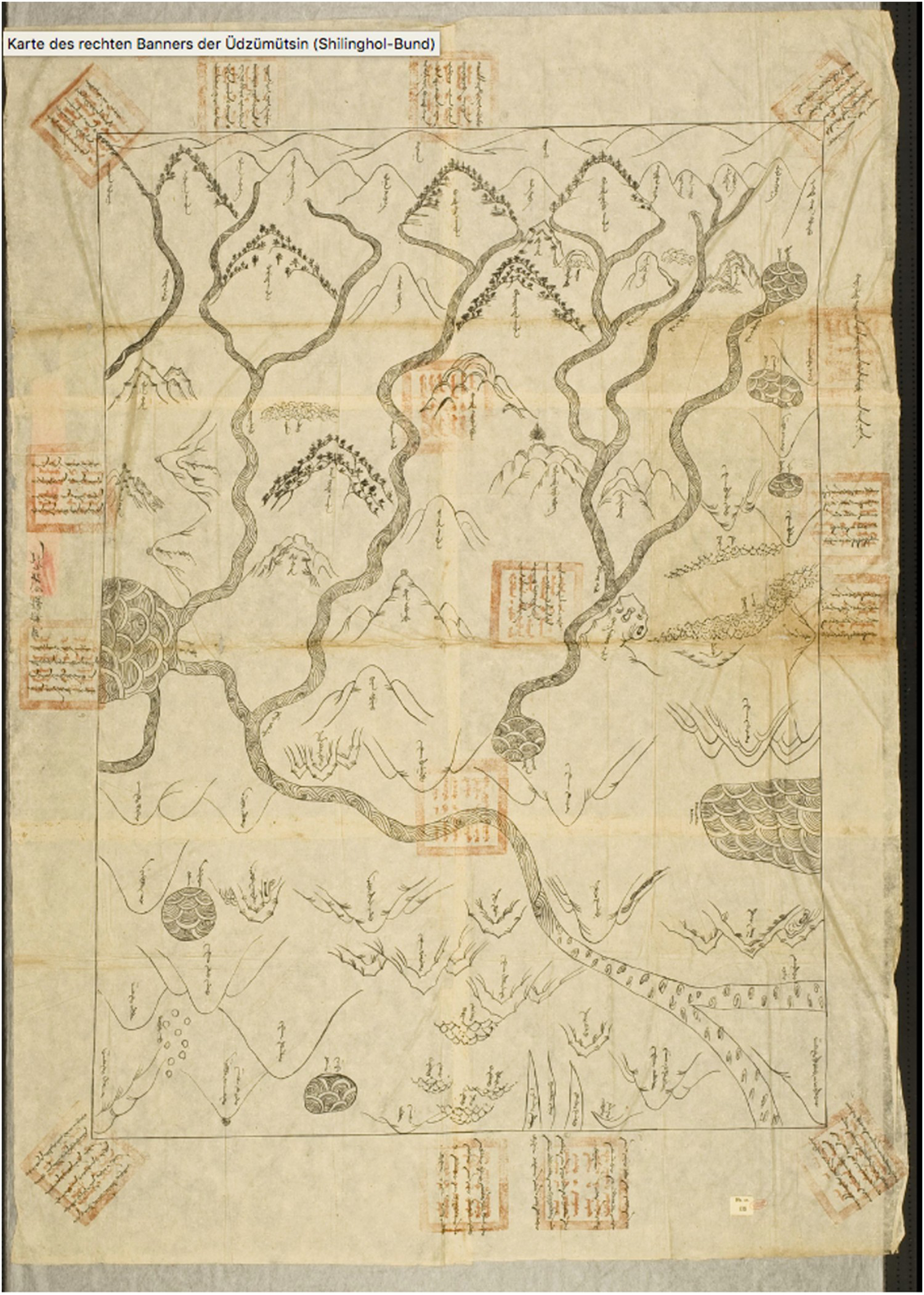
This map has no grid and does not indicate the cardinal directions. However, its rectangular shape is surrounded by 12 regularly placed inscriptions in the margins. These are written from ‘outside in’, each of them facing inwards to the centre of the map, such that they can only be read by holding the map and turning it round in one's hands. These inscriptions name the neighbouring territories in the 12 cardinal directions, so by reading them, we know that ‘south’ (emüne, ‘in front’) is at the top of the map from the reader's point of view. Thus, this map bears out Gell's basic argument, that both a local self-emplacement and a relation to abstract coordinates are necessary to understand where one is.
Yet there is a quirk to this document as a relational object, if one considers that it was made by the Qinwang of the Banner to be presented to the Emperor (via the Lifanyuan). Imagine handing a map to a high person. And imagine receiving it, if, as Smith (2013) argues, your cultural expectations were concerned with loyalty, hierarchy, tributary relations, and ritual correctness. It could be expected that the Mongol princeling would politely present his map in such a way that the high recipient could read it, i.e. the same way up as in the photograph. Now, Üzümüchin is northwest of Beijing. But in the map, the implicit position of the ‘I’ of the Banner chief residing in his lands is facing the wrong way – not southwards to the capital, but rudely with his back to the Emperor in the south, oriented towards the north at the bottom of the map.
The question of direction needs to be pursued further. First, it should be noted that the most commonly used Mongol directional words translated as ‘south’, ‘north’, etc. also have a possibly older and more primary meaning as ‘front/before’ (emün'e), ‘back/behind’ (khoitu), right hand (baragun), and ‘left hand’ (zegün). The Mongol language thus in fact juxtaposes an ego-centric system of spatial coordination with the ‘absolute’ one the Mongols were equally aware of, referenced by the sun and stars (for discussion of spatial coordination systems and language, see Levinson 2003). That ‘front’ does not necessarily mean ‘south’ is seen clearly in Illustration 4.
Lord Dugarsüren's Banner, Setsen Khan Aimag, Outer Mongolia, 1907.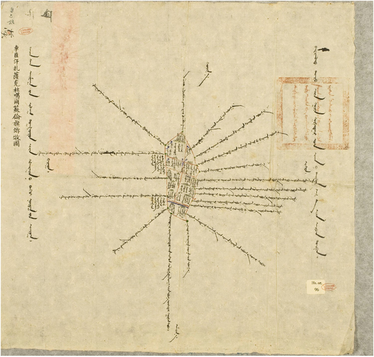
In this map, the slanting red grid lines dutifully represent the cardinal directions, while the written words ‘front’, ‘back’ etc. are clearly at an angle to them. The authors of this map are seeing themselves as facing forwards to the south-east, not the south. 15
Second, it is perhaps unnecessary to point out that the preoccupations of the mapmakers were not the same as those of officials demanding maps. Yet it was the local people who chose what to put into them and what to omit. Instead of documenting the useful resources, villages, roads, agricultural areas, mines, etc. asked for, some maps were primarily religious, i.e. almost entirely concerned to mark temples and other sacred sites. As can be seen in Illustration 5, apart from rivers painted thickly in red and the ruler's camp, almost everything else of note is a temple or an oboo.
Left Ordos Wang Banner, Inner Mongolia, 1911.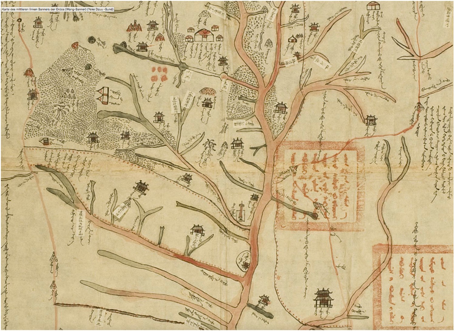
It is now possible to understand better another common type of map, which shows that points I have raised separately here (about ego-orientation, cardinal directions, and astrological/cosmological preoccupations) could actually be combined. Illustration 6 is an example of a genre of ‘cosmological self-placement’ more commonly found in Outer than Inner Mongolia but known in both regions. I have chosen to discuss it in detail because Chagdarsurung [Shagdarsüren] (1976) argued, based on his own research in Mongolia, that maps similar to this formed an indigenous Mongol map-making tradition stemming from the Yuan period.
Banner of Lord Dondubjalbupalmadorji, Tüsiyetü-Khan Aimag, 1907.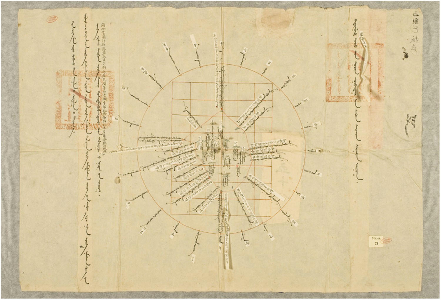
Here, to the reader's left is inscribed the numerous ranks and titles of the lord after whom the Banner is named. To the right is the date. The Banner is an irregular shape in the middle of a red-coloured grid, which is aligned with a set of coordinates arranged in a circle. These are the 12 animals of the cycle of years, with ‘horse’ at the bottom and ‘mouse’ opposite at the top. The animal cycle was of course known in China, but it was not used in cartography. In Mongolia, however, as Chagdarsurung describes (1976, 349), the zodiac animal signs were made to correspond not only with time measures (years, months, hours in the day) but also with the four cardinal directions. The latter were subdivided geometrically by the intervening lines, which were called the 8 ‘colours’, the 8 ‘angles’, and the 4 ‘corners’, giving 24 directions in all. These were indicated by their names written centrifugally on maps. 16 In this system, the horse sign represents astronomical south measured by the sun, and thus indexes not a relative but an invariant, ‘absolute’ system. If this ‘zodiac wheel model’ is a template that Mongol mapmakers had in mind, it can be seen that the 12 marginal inscriptions in Illustration 3, which are also written centrifugally, follow the same basic pattern. In Illustration 6, Lord Dondubjalbupalmadorji is placing himself and his Banner centrally in a set of abstract coordinates. This seems to be the main concern, since very little is depicted inside the Banner apart from a few hills beneath which are inscribed the names of various pastures (called ‘lands’ gazar). As a relational object, this map is more respectful than the map in Illustration 3. First of all, it appears to conform to the 1890 regulations mentioned earlier: Lord Dondub places his landscape within a grid as instructed, the mountains are all one way up, the ‘lands’ face south in the ‘horse’ direction in which the Emperor resides, and strips of paper with translations in Chinese are added for the inscriptions. In a way, this map has been made legible for its high recipient. Yet translating it into anything useful for a government must have presented a puzzling task. No visual indications are given about the surrounding territories. One sees where this Banner is cosmologically, but not in practical geography.
The boundary-marks, the oboos, are not much help in this regard. However, the system for designating their geographical relation to one another was sophisticated and precise. Each oboo is place-named with an outward-directed inscription in all four directions. As studies of Mongol maps describe (Chagdarsurung [Shagdarsüren] 1976; Kamimura 2005; Futaki 2005), each map was supposed to be accompanied by a handwritten ‘locality report’ (nutug-un chise) providing details of the orientation and distances between boundary marks, which in principle should yield the dimensions of the Banner as a whole. Chagdarsurung transliterates one such report,
17
from which we see that the units of distance used were a mixture of Mongolian and Chinese measures: the gazar, qubi, alda, and the chi. The Manchu official receiving it would be faced with a puzzling document, since the report does not mention whether the ‘gazar’ taken was the Mongol 500 double-steps or the Chinese li. Many of these reports read less like a number of measurements than a list of enchanted connections. For example:
From the first White Plateau oboo in the joyous northwest to the second Black High Peak oboo at the source of the small spring in the direction of the interstice between ‘Profit’
18
and ‘Snake’ to the interstice between ‘Pig’ and ‘Eternity’
19
, [is a distance of] 18 gazar, 5 qubi, and 2 alda. And from this to the third oboo at the pass to the west of the steep mountain … . (Chagdarsurung [Shagdarsüren] 1976, 351, trs. C Humphrey)
One further point should be made about the map and report quoted by Chagdarsurung and others like it. They essentially recorded notional journey distances, and this is reflected in the language used in some reports, which uses the word ‘going’ (yabu-) (Futaki 2005, 57–59). ‘Going’ is implicit in the quotation above from Chagdarsurung [Shagdarsüren] (1976, 351), where the map-maker operates by ‘taking a direction’ for travel by picturing the diagonal line between two animals on either side of the circle, and then, moving in that line, measures the distance between one oboo and the next. It is unlikely, given that the Mongols’ means of transport at this period was the horse, camel, or ox, with the measuring technology of a rope or perhaps pacing out the steps, that mapmakers could actually have measured the physical distances – perhaps across mountains or forests – with the degree of precision cited in the reports (down to around 1 m). The written reports, therefore, seem to have a rhetorical character, gesturing to exactitude. However, the practice of calculating orientation by opposite pairs of 24 symbols across a circle did enable a fair degree of precision in locating the relation between objects in the landscape. This wheel-like model must have existed as a mental construct of the Mongols so robust that most maps do not need to depict it on the page, even though their accompanying textual reports refer to it (see reports cited in Futaki 2005). After all, it was an everyday presence for all dwellers in the Mongol ger (circular yurt). The roof of the ger was supported by a wheel of wooden spokes which Mongols aligned with the 12 animals, and they told the time by seeing where the sun's rays fell in relation to the animal-symbol positions.
I would suggest also that a ‘wheel’ image of the animal symbols must have operated as a key component of ‘mental maps’ that were shared by Mongols going about their lives as herders. Living in the domain of the Banner, and being forbidden to pasture outside it, herders would be concerned with routes and distances across it, not the lengths around the rim that the mapmakers had to trace. Thinking of traversal across the land,
21
they would be interested in the distances between different kinds of pasture, wells, high mountain passes, monasteries, and other features dispersed across the whole of it. They would not need paper maps for wayfinding.
22
Assuming that everyone could observe the position of the sun and held the animal-symbol directions in their heads, routes could be indicated verbally by instructions (in approximately the same laconic form as that used in the reports attached to maps). Yet the maps, which lay out the relations between places visually, indicate a central way that Mongols thought about territorial spaces, that is, to conceive them holistically. This is implied by the use of the word nutug, rather than qoshigu (Banner) for most of the maps; nutug means ‘home territory’, an assembly – one could even say, a companionship – of dispersed yet inter-related land resources. In this context, it is worth referring to a map that is an exception to the series so far discussed because it seems not to have been produced to central government order (Illustration 7).
23
Shajintohai district of Alasha Banner, Inner Mongolia.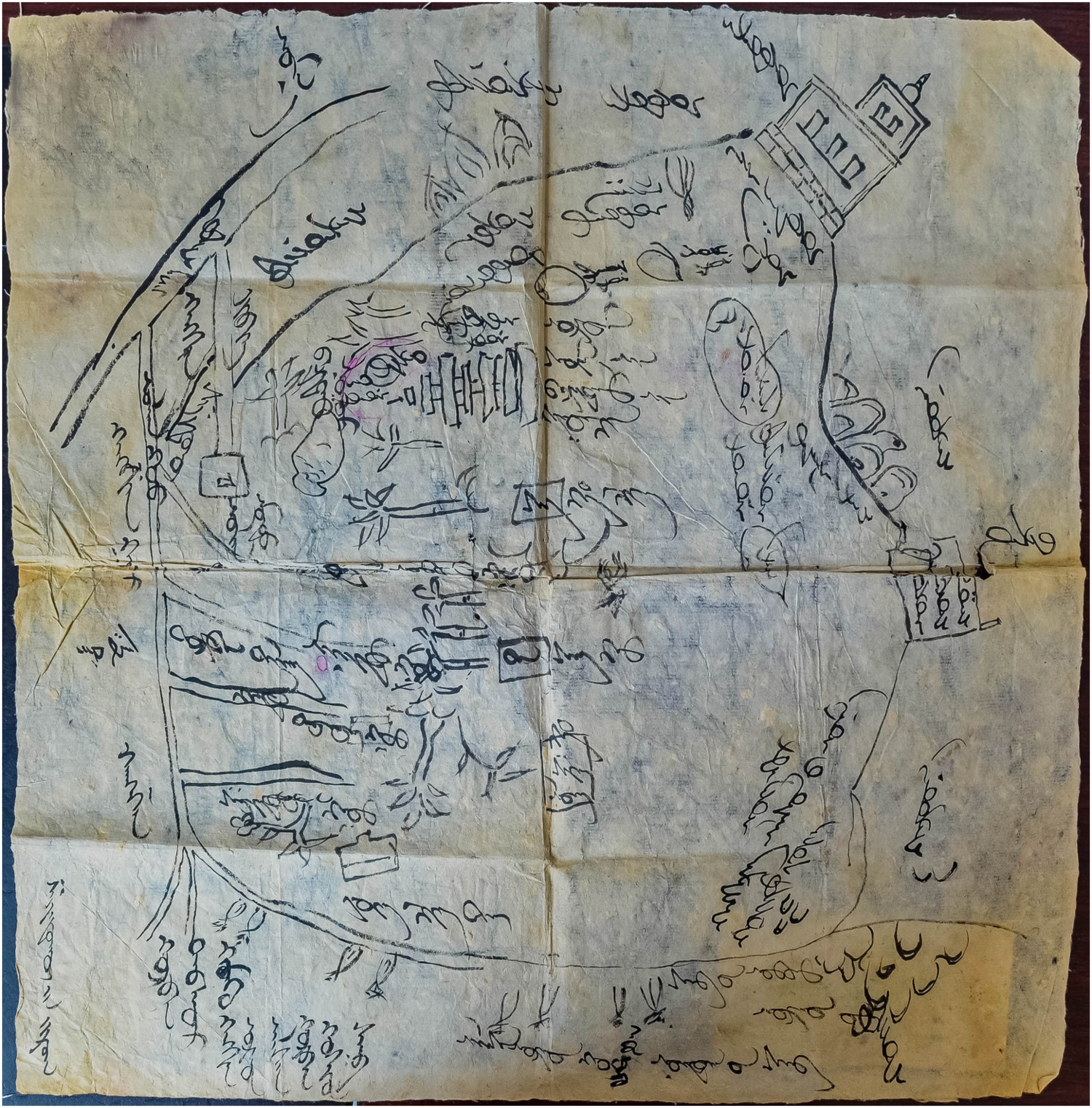
What we seem to see in this map is space imagined in a circular manner, as if conceived by someone free to turn 360° and see all around. The cardinal directions (emüne, etc.) are clearly marked, but they, off at an angle, have nothing to do with the rectangle of the page. This map, refuses, as it were, the discipline of ‘the document’. The writing, the temple, the trees, and the pagoda are depicted from different and even opposite positions. This is dizzying if one imagines a map as having an external ‘right way up’, but it is understandable if what is being shown is this place from inside, as it is lived in. The scattered disposition of objects and the concern with movements by people and herds diagonally amongst them are features that this map has in common with the Banner maps and with Marzan Sharav's painting. All represent a flattened ‘landscape’ of widely distributed happenings, with implied ‘irregular’ (non-rectilinear) journeys from one to another. The Banner maps that are charted in relation to the circle of signs are also saying something else. Each item or event must happen somewhere in geographical space, and the very nature of that point is that it is at the same time an astrological–cosmological location. This is of the greatest concern, since correct alignment of one's astrological self with these spots determines the fate of one's endeavours.
Conclusion
The great majority of Qing-era Mongol maps were produced to order, for a political authority. But despite the hardening of Qing regulations for signage and cartographical standards at the end of the nineteenth century, the huge variety in the maps show that in practice the Mongols continued to follow their own ideas of how to make a map. Very probably, the draughtsmen monks would have known about diverse cross-Asian traditions of cartography, including the Tibetan, the Chinese, and even in northern Banners the Russian. At least some monasteries were host to lamas deeply interested in physical geography of the world beyond the Qing Empire (Kapstein 2011). Possibly some draughtsmen knew about successive Qing Emperors’ concern with latitude and longitude, and some are likely to have been aware of traditions of map-making in China that ignored these scientific techniques and chose an altogether different rationale. So, in my view, it would incorrect to see Mongol mapmakers as naïve. A range of possible kinds of the map was available to them: they could choose whether to deploy an ego-oriented representation of landscape or not, which system of coordinates to use, whether to depict a grid, which system of measurements and scale, and whether to make the map schematic or something verging on a realistic landscape painting.
In very general terms, we can say that in making a map of a Banner, the ruler and his draughtsmen were also making a map of a way of life. It is noticeable that the elegantly written titles refer to qosigu [khoshuu] nutug (Banner homeland), the word nutug being a multi-scalar notion of ‘familiar territory/homeland’. It is noticeable that in the great majority of maps, the most prominent features are mountains, normally individually named and depicted side on, with the worshipped ones carefully marked. As I have described, the ruler often inscribed himself, in his own person and own pastures, into this domain. And commonly, the mountains are depicted facing as they would have looked from the point of view of this ruler moving through his domain (see Illustration 3). As Alfred Gell observed, there is nothing naïve about such self-insertion. He argued that what was required in order to understand where one is (to have a ‘mental map’ of one's location) is some method by which to relate the bodily position to external coordinates that are independently true (Gell 1985, 279–280). The Mongolian practice of map-making did this in a variety of ways, sometimes more implicitly than explicitly, and usually by having in mind the ‘wheel’ of symbolic cosmological coordinates that the Buddhist culture taught to be independent and universal. In everyday life, the system of astrological signs was used to coordinate time with spatial orientation; in other words, it determined the auspicious moment linked to the favourable direction for any important activity, journey, or life-event. When embedded in a complex matrix with zodiac-signs, celestial movements and constellations, spirits, elements, etc. this was specialist knowledge encoded in divination manuals (Bauman 2008). But these relational patterns applied to everyone, to groups, great rulers, animals, and omens, and also to non-human occurrences, such as floods or epidemics. For ordinary people, the basic principles of coordination of the system formed a skeletal framework for an extraordinarily holistic way of thinking, which, I have suggested, underlay the making of Mongolian maps. This can be seen most clearly in Marzan Sharav's spatialization of time-specific activities in his ‘One Day’ map–painting. But in various different ways, the Banner maps show its influence too. Most of them are hybrids that demonstrate the many-layered palimpsest that constitutes ‘the local’; but in the practice identified by Chagdarsurung [Shagdarsüren] (1976) with a specifically Mongol tradition, the nutug ‘homeland’ is never shown as a section of land demarcated from the surrounding territory but rather as a unique domain suspended solo between coordinates. This was the case even if the coordinates were taken for granted and not graphically specified. Map-making thus functioned to define a subject of cosmology, perhaps more so than a political entity.
Footnotes
Acknowledgements
I am very grateful to Baasanjav Terbish, Christos Lynteris, and Tom White for their ideas and information, which helped me greatly in writing this article and to the two reviewers for their insightful comments. I would also like to express my gratitude to Dulamjav Amarsaikhan and Uranchimeg Tsultem for their invaluable assistance.
Disclosure statement
No potential conflict of interest was reported by the author(s).
1
2
The example given by Gell is the statement, ‘King's Cross is north of here’, a statement that depends on the location of ‘here’; but the truth value of this statement depends logically on the existence of the spatial proposition of the relation between North and South, which is independent of the location of ‘here’ (![]() , 279).
, 279).
3
Hallpike (![]() , 342–343) issued a rejoinder to Gell in which he rejected the epithet ‘behaviouristic’ and the description of his belief, along with that of Bourdieu, as the idea ‘that primitive spatial concepts and direction finding are “subject centred” and based on practical mastery’. He argued that Gell had neglected his reference to topological relations, such as proximity, order, inclusion, and separation, which can provide a system of objective orientation without the need for Euclidean or projective representations. For this and Gell's rejoinder, see Man N.S. 21.2: 342–346.
, 342–343) issued a rejoinder to Gell in which he rejected the epithet ‘behaviouristic’ and the description of his belief, along with that of Bourdieu, as the idea ‘that primitive spatial concepts and direction finding are “subject centred” and based on practical mastery’. He argued that Gell had neglected his reference to topological relations, such as proximity, order, inclusion, and separation, which can provide a system of objective orientation without the need for Euclidean or projective representations. For this and Gell's rejoinder, see Man N.S. 21.2: 342–346.
4
The maps available for this study are by no means all that are preserved in various collections. The Imperial Mongols of the Yuan Dynasty had maps; the defeated Mongol general is recorded as having handed over his maps to the victorious Ming, but they seem not to have survived (see Chagdarsurung [Shagdarsüren] 1976, 345–346 and Herb ![]() , 682 for discussion of early Mongol maps and even a globe). Perdue (1998, 279–281) discusses a map made by the Zhungar leader Galdan Tsering in the seventeenth century. Apart from such scant sources, the maps made by Mongols known to modern scholarship date almost entirely from the 1790s onwards. It should be noted, however, that a considerable number of maps not available to me are held in Mongolian collections and some of these may date from earlier periods. I have also not had access to the study by Oyunbeleg (2014) published in China of the Tenri Central Library collection. The maps used for this article are: 9 hand-drawn maps from the Kotwicz archive, dated variously 1805–1912 (Inoue 2014); 182 digitized copies of maps held in the State Library of Berlin, dated 1830s–1930s; and 44 maps held in the Tenri Central Library in Tenri, Japan (Futaki 2005). See details of these holdings in Herb (1994, 682). Courtesy of Dr Tom White I also have access to several undated hand-drawn maps from the Alasha government archives.
, 682 for discussion of early Mongol maps and even a globe). Perdue (1998, 279–281) discusses a map made by the Zhungar leader Galdan Tsering in the seventeenth century. Apart from such scant sources, the maps made by Mongols known to modern scholarship date almost entirely from the 1790s onwards. It should be noted, however, that a considerable number of maps not available to me are held in Mongolian collections and some of these may date from earlier periods. I have also not had access to the study by Oyunbeleg (2014) published in China of the Tenri Central Library collection. The maps used for this article are: 9 hand-drawn maps from the Kotwicz archive, dated variously 1805–1912 (Inoue 2014); 182 digitized copies of maps held in the State Library of Berlin, dated 1830s–1930s; and 44 maps held in the Tenri Central Library in Tenri, Japan (Futaki 2005). See details of these holdings in Herb (1994, 682). Courtesy of Dr Tom White I also have access to several undated hand-drawn maps from the Alasha government archives.
5
Some such spike years were 1891, after new mapping regulations were issued in 1890, 1907, when the Qing undertook research on economic resources in Mongolia, and 1911, after the announcement of the New Policy whereby the Qing officially lifted the ban on Chinese settlement in Mongolia and planned to open the country to development. These initiatives along with the calls for maps were a response to the threat of Russian advances (Kamimura ![]() , 15–16).
, 15–16).
6
However, several of the maps in the Kotwicz collection are of whole Aimags with their constituent Banners (Inoue ![]() ). This can be explained by the fact that these maps were collected in Da Küriye (later Ulaanbaatar) in 1912, after Outer Mongolia had declared independence from China. The new Mongol government had an interest in consolidating their lands, not dividing them. The Aimag maps seem to have been conceived as the parts of a map of the whole of Mongolia.
). This can be explained by the fact that these maps were collected in Da Küriye (later Ulaanbaatar) in 1912, after Outer Mongolia had declared independence from China. The new Mongol government had an interest in consolidating their lands, not dividing them. The Aimag maps seem to have been conceived as the parts of a map of the whole of Mongolia.
7
Oboos at which the Mongols carried out rites of worship to spirits of the land were marked differently on maps from boundary oboos and were often situated in the interior of Banners; nevertheless, I have argued elsewhere (Humphrey ![]() ) that these oboos, which were usually set on mountain tops or high passes, did mark the edge of socially recognized pasturing areas.
) that these oboos, which were usually set on mountain tops or high passes, did mark the edge of socially recognized pasturing areas.
8
9
10
An exception to hand-drawing is the printed map of Wutaishan, the complex of sacred mountains in north-eastern China, made in 1846 by a Mongolian Buddhist lama. This was carved on woodblocks and the prints were then coloured by hand. This map can also be seen as a landscape, in that it takes a single sideways (not vertical) perspective and does not include nomenclature written inside the image. See discussion in Chou (![]() ).
).
11
12
See Kamimura (2005, 16–19) and Chagdarsurung [Shagdarsüren] (![]() , 368) for further discussion of these measures and their putative equivalents in the metric system. According to the latter, the gazar was 576 m, the qubi was 1/10 of a gazar, and the alda was 1.6 m.
, 368) for further discussion of these measures and their putative equivalents in the metric system. According to the latter, the gazar was 576 m, the qubi was 1/10 of a gazar, and the alda was 1.6 m.
13
See Chan (![]() ) for a discussion of the use of the bowshot as a measure of length in Asia and the Altaic world specifically. In early Mongol texts, the basic unit of measurement was the alda (outstretched arms span) and the bowshot feats of heroes were given as amazing distances counted in alda (Chan 1995, 36–37).
) for a discussion of the use of the bowshot as a measure of length in Asia and the Altaic world specifically. In early Mongol texts, the basic unit of measurement was the alda (outstretched arms span) and the bowshot feats of heroes were given as amazing distances counted in alda (Chan 1995, 36–37).
14
In several of the map inscriptions, ‘I’ is written as minii bey-e, ‘my body’, which can be related to the bodily stance that lies behind many Mongolian spatial concepts.
15
The Mongols situate themselves and place the doors of their ger (yurt) facing forwards/in front. In central Qalqa/Khalkha ‘front’ (emüne) is south or slightly south-east, but for the Western Mongols ‘front’ veers round to east. A distinction between fixed and moveable objects is made in modern Mongolian. A herder might say, ‘My herds are pasturing in front’, but not necessarily mean to the south. However, if he is in north Mongolia standing with his back to the town Mandalgov’, he would use emüne to describe the town's situation.
16
The centrifugal writing on Mongol maps was probably a matter of convenience for the scribe, since, written from top downwards, a label could more easily be attached to a point by starting there rather than attempting to end there.
17
18
Orulta /orulg-a, ‘profit, income bringer’, one of the 4 zobkis (‘corners’) equidistant between two of the four cardinal directions.
19
Möngke, ‘eternity’, one of the 4 zobkis.
20
21
This is clearer in the 1925 report of a Buryat Banner quoted by Futaki (![]() , 59), which gives each distance in the form ‘if one travels from X oboo in the X sign direction it is X distance to X oboo’. In these reports, directions are common cited in terms of the astrological signs in preference to the ambiguous emüne, etc.
, 59), which gives each distance in the form ‘if one travels from X oboo in the X sign direction it is X distance to X oboo’. In these reports, directions are common cited in terms of the astrological signs in preference to the ambiguous emüne, etc.
22
According to my informants, even people setting out on long pilgrimages from north Asia to Tibet did not use maps but relied on the local knowledge of guides from place to place along the way.
23
The map, labelled bottom left, depicts the Yellow River (top left) and channels flowing from it, possibly for irrigation. The district had considerable Chinese settlement, denoted by named squares, and the map may have been made in connection with land disputes with Mongols. No Mongol government site is visible and the map features rather religious objects such as a monastery, a possibly ruined pagoda (suburgan), and sundry oboos ranged along the lines that seem to depict a boundary.