
Abstract
This paper is focused on finding an optimal strategy for enhancing the consensus on negotiations over the legal status and regime problems of the Caspian Sea, which has caused a lot of abortive strives since the collapse of the Soviet Union. The strategic planning process begins with finding a set of major closed sea that has similar geographical features alike Caspian Sea. Then based on expert ideas and background review, it generates a series of fundamental criteria that have influenced the closed sea delimitation. Through a committee of practical experts with diversified professional backgrounds, these criteria were evaluated and classified into internal strengths and weaknesses of the alternative closed sea, as well as external opportunities and threats to them. The Delphi technique also was used to establish expert consensus on key strategies that are important for delimitating the Caspian Sea. In the next section, the decision makers (DMs) determined the factors weight based on the vast amount of information concerning the closed sea delimitation conditions. Then these factors have been weighted based on the Caspian Sea coastal countries’ conditions. Finally, this paper assesses the strength, weakness, opportunity and threat (SWOT) of these criteria, and develops an optimal strategic plan for the Caspian Sea delimitation that can enhance the consensus on Caspian Sea legal regime in future negotiations.
Introduction
After appearance of three new states on the shores of the Caspian Sea, the delimitation of the Caspian Sea on the national sectors basis is a complex multi-criteria problem with conflicting objectives (Mojtahed-Zadeh & Hafeznia, 2003). The Caspian Sea is unique in many reasons: the large deposits of oil and gas; valuable fishery resources, including 90% of the world's stock of sturgeon; important transportation routes; connecting the European part of Russia, Transcaucasia and Central Asia; and significant geopolitical situation. Figure 1 presents the location of the Caspian Sea and the five coastal countries of the Caspian Sea region considered in this study.
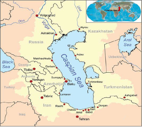
The location of the Caspian Sea and five coastal countries on a map of the Caspian Sea region.
The unexampled characteristics of the Caspian Sea led to a problematic identity and stopped its prepared legal classification. It has alternatively been called a lake, an enclosed sea, a closed sea, a semi-closed sea, a sea, an inland sea, and finally a “unique body of water.” From the maritime law viewpoint, the legal status of the Caspian Sea should also be determined when the coastal states factually recognized which body of law applies to delimitation of the waters and the resources of the subsoil (Butler, 1971; Ghafouri, 2008; Joyner & Walters, 2006; Kubicek, 2013; Zimnitskaya & Geldern, 2011). Because of the complex nature of Caspian, each of the coastal countries has a different interpretation for the Caspian delimitation and this leads to considerable tensions among them. The absence of a suitable legal status amplifies these tensions because the present legal regime of the Caspian Sea, which is based on the Soviet–Iranian agreements concluded more than 50 years ago, is no longer sufficient to deal with the host of complex political, economic and environmental problems that exist in the area (Aghai-Diba, 2003; Aqayi, 2006). The two countries enjoyed a stable relationship based on the treaties of 1921 and 1941. Determining a new legal regime that delineates the territorial borders, along with the right to access to the natural resources, has been the source of conflict among the current five littoral countries of the Caspian Sea. The discovery of abundant oil and gas resources in the Caspian Sea has significantly added to the complexities of this conflict, especially with the newly independent states of Azerbaijan, Kazakhstan, and Turkmenistan in desperate need of accessing Caspian Sea's valuable oil and natural gas resources. Currently, the five states bordering the Caspian Sea are in dispute over who owns which part of the sea, or whether the five states share the entire sea in some sense. However, during the last twenty years, for balancing the present legal regime and holding on to peace, the five littoral states have met on about 30 occasions, at the presidential, ministerial and expert levels, in all five states and in many different cities (Madani, Sheikhmohammady, Mokhtari, Moradi, & Xanthopoulos, 2014; Mamedova, 2009; Sheikhmohammady, Hipel, & Kilgour, 2012; Sheikhmohammady, Kilgour, & Hipel, 2010; Zonn, Kostianoy, & Kosarev, 2010). Tehran's meeting in 1992 was the first international conference that raised the question of Caspian Sea's status among the costal countries. The conference concluded in a joint pronouncement on 4 October 1992. All five costal countries accepted to define a mutually interested field in the Caspian Sea, saving the natural resources and natural reserves; conservation, reproduction and optimal utilization of the biological resources; development of mineral resources with due account of economic interests of the Parties; determination of rational sea lanes with due account of environmental requirements; and control of the level of the Sea. The controversial approach to this issue adopted by some of the coastal States is particularly evident in the context of the ongoing multilateral negotiations aimed at drafting a framework Treaty on Regional Cooperation in the Caspian Sea. The draft Treaty, prepared by Iran in consultation with other interested States, was completed in 1993. The draft is based on the notion of cooperation of Caspian States in the utilization of the Sea, which is regarded as a unique environmental system of particular importance to all coastal States. The draft provides for the establishment of a regional organization of Caspian States as an institutional framework for future activities, the decisions of which would be based on the principle of consensus. The draft Treaty rejects the idea of the partition of the Sea between coastal States, as well as any unilaterally asserted territorial claims (Vinogradov & Wouters, 1995). In the next meeting, which was held in Ashkhabad conference (14 September 1993) and the year was closed by Ashkhabad Conference (8–10 December), the matter of establishment of international organization on Caspian Sea was raised again. Turkmenistan passed a 1993 law unilaterally declaring its jurisdiction over a 12-mile coastal zone on the Caspian in accordance with the rules of the UN Convention on the Law of the Sea of 1982 (UNCLOS). Later, Azerbaijan described a part of the sea as national territory in its constitution. It began issuing licenses in 1994 for exploration and development of hydrocarbons at sites within its proclaimed sector. These unilateral actions were protested by Russia by means of diplomatic notes, which were not replied to neither by Azerbaijan nor by Turkmenistan (Karbuz, 2010). And then one of the important conferences was held on 11–12 October in Moscow, when the proposals of Azerbaijan, Kazakhstan and the Russian Federation over the status of Caspian Sea were discussed. Azerbaijan's approach was to consider Caspian Sea as a Border Lake delimited by respective sectors. And according to Kazakhstan, Caspian Sea was considered as “enclosed sea” as per UNCLOS Part IX. These proposals were severely opposed by Iran and Russian Federation, which led to rejection of them both. Russians’ proposal, which was leading to the condominium of the Caspian Sea, was opposed by Azerbaijan and Kazakhstan. Five costal states were determined to create an efficient system of permanent mechanism of negotiations (working groups) on the legal status of the Caspian Sea. This was achieved during the Almaty conference of 1995, which began a new era of cooperation between the costal countries. The working group first met in Tehran and then in Almaty. Major principals of these meetings were to respect each other's sovereignty and territorial integrity, to pronounce the Caspian Sea as demilitarized zone and a territory for only peaceful goals, conservation of marine life, environmental matters, decreasing the pollution, etc. (Aghai-Diba, 2000, 2003, 2010a, 2010b; Mamedov, 2000).
The parties participating in these conferences could not reach a solid agreement on the status of the Caspian Sea in all the conferences in 1995–1996. Since 1997 these conferences gradually became more universal and widened. The next meeting of costal states about the subject of elaborating and adopting an agreement on the legal status of Caspian Sea was in Astrakhan in 24–27 June 1997. The Russian Federation and Kazakhstan reached an agreement in 1998 in which they delimitated the Caspian Sea bed between the two countries. This clearly indicated that the negotiations between these neighboring states became more desirable for these parties rather than the negotiations between all the involving countries, where reaching an agreement seemed to be impossible. Following this, the delimitation documents were signed by Russian Federation and Azerbaijan in 2001. Cooperating groups conducted frequent meetings in 2000–2002, and in January 2002 the official announcement was signed in which they elaborated the convention on the legal status of the Caspian Sea (Lee, 2005; Mamedov, 2000, 2002). The first summit of the heads of littoral states of the Caspian Sea took place on 23–24 April 2002 in Turkmenistan to determine a new legal status for Caspian Sea. However, the summit failed to make any important steps toward the legal status of the Caspian Sea, and ended without any progress. They could not find a single position and Iran strongly opposed the united position of the Russian Federation, Azerbaijan and Kazakhstan. Turkmenistan's general idea was supporting the division of the sea bed of Caspian Sea. Yet it was not fully supportive of the joint party's position. Iranian party had a firm position of either dividing the Caspian Sea bed to 5 equal sectors between the littoral states or apply the condominium principals agreed on the 1921 pact. Although this summit did not bear any fruit, all the littoral states agreed that it was a good start. On the contrary, it triggered new tensions among the littoral states, especially between Azerbaijan and Turkmenistan (Abilov, 2013). In May 2003 in Almaty during the 9th meeting, an agreement was signed between Kazakhstan, the Russian Federation and Azerbaijan on the delimitation of the Caspian Sea among these countries. Based on the above mentioned agreement, the Russian Federation gained 19%, Kazakhstan 29% and Azerbaijan 18% of the Caspian Sea bed. But Iran proclaimed that the agreement does not comply with the international law. In the next meeting the only achievements were some drafting progress (mainly of environmental nature) (Aghai-Diba, 2003; Mamedova, 2009). On 16th October of 2007, on the second presidential negotiating meeting for the declaration of a legal status of the Caspian Sea held in Tehran, the participating parties mainly focused on security matters. And the Russian Federation reflected its concerns over the matter of participation of foreign military forces in the Caspian Sea in joint declaration. The lack of resolution has resulted in the Tragedy of the Commons, where petroleum production and overfishing contribute to the environmental degradation of this valuable natural resource (Sheikhmohammady et al., 2012). During the third summit in Baku, the leaders of the five littoral states of the Caspian Sea signed an agreement on security cooperation, which was one of the main points on the summit's agenda. According to that agreement, only the littoral states are responsible for the security and the protection of the Sea. The reason for the security agreement was the naval forces in the Caspian Sea. During the Baku summit, the leaders discussed the settlement of 25 miles national sector in the Caspian Sea and a ban on sturgeon fishing. At the end of the summit, the presidents of the coastal countries confirm their attention to complete work on the convention on the legal status of the Caspian Sea. This convention will be the basic document that will regulate the activities of the littoral states in the Caspian Sea. However, the Baku summit also failed to make any progress on the Caspian Sea legal status (Abilov, 2013). During the last meeting of the working groups, the participants announced their readiness for signing the convention in 2013. According to the report of Voice of Russia correspondent Kira Kalinina, Russian Foreign Minister Sergei Lavrov has said that the Foreign Ministers of the five Caspian Sea littoral states, namely Azerbaijan, Iran, Kazakhstan, Russia and Turkmenistan, are due to meet next in Moscow in Spring 2014 to determine the legal status of the Caspian Sea. The negotiations about determining the new legal status of the Caspian Sea are still ongoing (http://voiceofrussia.com/news/2013; Abilov, 2013; Formentini & Milani, 2012). It is of great importance to remember that the coastal states and the characteristics of their relations do not have so much disagreements as taking into account the important role of the Caspian territory in global geopolitical deals of today's world, which are expanded by the United States, Europe, and China. It is obvious that these states today have their own interests in this region. For example from the perspective of US policy-making officials, the Caspian region's geo-strategic dimensions for the United States have not been limited to energy security issues; they have implications for the grand strategy of the United States in the twenty-first century: “the US not only aims to politically control regional energy resources, in particular Kazakh oil, but also checks potential challengers to its grand strategy such as China and Russia (Blank, 2012; Iseri, 2009; Zabortseva, 2012).
Thus, in this study, to enhance the consensus on Caspian Sea legal regime in reaching a sustainable agreement, a strategy was developed based on the hybrid Delphi–SWOT model. As shown in Fig. 2, in the first step, many affected parameters, such as geographical, economical, political, environmental, cultural, and social, were recognized based on literature research and expert opinions. For this a Delphi method was applied in step 2 to delete insignificant factors and select the important ones. A group of informed individuals to pool expertise from many domains and who will evaluate several factors that are affected by alternative delimitation was established. The group included seven senior managers who were highly educated. Three managers held graduate degrees in political geography, two held a graduate degree in legal science, one held a graduate degree in management, and another held a graduate degree in economics. Despite being educated, the members’ managerial judgment was limited by their own experiences and background. Not to mention, all seven group members were expert managers and have more than a decade of experience in pelagic law centers and in the humanity and social science departments in universities. Because they possess different kinds of knowledge and background, it was more likely that all aspects of the decision were considered by group members. The group also received additional assistance from 18 experts and researchers, including authors working in different government research centers and universities from Iran, United States, France and Germany who collected information and interviewed different stakeholders involved in pelagic delimitation during the course of 2 years.
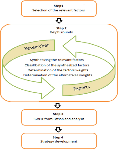
The core steps of hybrid Delphi–SWOT model and its actors.
In the next step, all key factors were classified into prevalent categories and collectively considered into SWOT (the acronym standing for Strengths, Weaknesses, Opportunities and Threats) analysis and their weights were determined. Also, the five coastal countries have been weighted based on these key factors. Finally an action plan for the bordered countries was developed by SWOT analysis. Consequently the endorsement of the executive managements in the implementation of the action plan has been achieved. The paper aims to serve as a strategy plan for optimizing the consensus on the Caspian Sea legal regime, aside from proving that the hybrid Delphi–SWOT model can be practical in geopolitics and political geography related issues and make hybrid Delphi–SWOT research more efficient in the above mentioned areas.
Delphi technique
The Delphi method is an effective and efficient technique and a structured group process that comprises a panel of selected experts who are identified as people who bring experience and expertise to a question or problem in their field (Cowan, Brunero, Lamont, & Joyc, 2013). The Delphi survey is performed in several rounds, and in each round participants communicate their opinions through a questionnaire that is returned to the researchers, who collect, edit, and return to every participant a statement of the position of the panel and the participant's own position. This refinement procedure is continued until an a priori defined criterion (e.g., consensus) has been achieved (Yap, Pilkington, Ryan, Kelly, & Jorm, 2013). Generally, there is a convergence of opinions after three or four rounds, and a stabilized group opinion emerges (Ndour, Force, & McLaughlin, 1992). The first round of the Delphi technique repeatedly involves the generation of opinions, and these data are categorized into subcategories. These data are given to the panel on second round to vote, so that they again produce quantitative data. The third round repeats the procedure on the second round, but it also presents the panelists the statistical summaries of the second round together with any comments. Participants are usually eager to reconsider their initial answers, which are breakthrough in achieving a consensus (Antcliff et al., 2013). This group opinion may reflect agreement, disagreement or some of each. The optimum number of participants depends on the number needed to have a representative pooling of views (Ndour et al., 1992). The Delphi technique is anonymous, however, and does not require simultaneous participation (Wihlborg et al., 2014), and the technique can also use a series of questionnaires to collect data from a panel of geographically dispersed participants (Paré, Cameron, Poba-Nzaou, & Templier, 2013). Currently, the Delphi method is used as a research instrument within fields as diverse as the physical sciences, engineering, education, public administration, biological science, health care, business economics and policy making, as well as sustainable development (Alyami, Rezgui, & Kwan, 2013). The key stages of the Delphi technique in this study are (1) selection of the Delphi panel, (2) the development of Delphi questionnaires, (3) data collection process and (4) data analysis cooperated with SWOT implementation.
SWOT analysis
Since its inception in the early 1950s, SWOT analysis has been used with increasing success as a strategic planning tool by both researchers and practitioners. The technique is used to segregate environmental factors and forces into internal strengths and weaknesses, and external opportunities and threats (Hatami-Marbini, Tavana, Hajipourc, Kangi, & Kazemi, 2013). Conducting a SWOT analysis is a simple but effective strategic planning tool to allow the organization to be recognizant of these factors (Eslamipoor & Sepehriar, 2013). Many researchers applied SWOT analysis as an effective tool in strategy formulation that supports strategic planning and decision-making (for more detail, see Hosseini Nasab & Milani, 2012;Kajanus, Leskinen, Kurttila, & Kangas, 2012). The initiating step for strategic planning is creating the mission and targets of the organization, and then the SWOT analysis, which is one of the instruments for rearranging the strategy it shapes for the organization that is tailored to its environment. Using this analysis, it is possible to analyze first the internal and external environments, and second the strategic decisions to be taken for harmonizing the organization's strengths with the opportunities of the environment (Sherej Sharifi, 2012; Tavana, Pirdashti, Kennedy, Belaud, & Behzadian, 2012).
Hybrid Delphi–SWOT model
The hybrid Delphi–SWOT model proposed in this study is used to develop an optimum strategy for the Caspian Sea delamination to enhance the consensus on Caspian Sea legal regime in future negotiations. Figure 3 presents the strategic planning model used in this study. It was a tri-stepped process: 1) problem definition and phase design by Delphi rounds to conclude, 2) evaluation phase applied SWOT analysis to plot the final strategy and 3) development phase; also DMs completely agreed that the suggested outline in Fig. 3 provided invaluable analysis aids and data processing support.
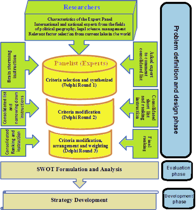
Strategic planning model.
Problem definition and design phase
Ambiguity of the geographical classification of the Caspian Sea
Existing international conventions are not readily applicable to the Caspian
Sea as the international scientific and political communities have not yet
developed a consensus over classifying the Caspian Sea as a sea or a lake.
If Caspian Sea is to be considered a lake, a condominium regime might be
applicable under which no country has exclusive right and a joint
sovereignty will govern the lake. However, being the largest enclosed water
body on earth by area and having oceanographic characteristics that are
typical of seas put the applicability of the Condominium regime into
question. As a sea, Caspian Sea could be divided using equidistance median
lines, based on the International Law of the Seas. Under this law, also
referred to as the ‘sectorial division’ method, each country has exclusive
rights within its maritime boundaries. During almost two decades of
negotiations, five major governing/sharing methods have been proposed by the
riparian states: Condominium status applying to both the
surface and the sea bed Division based on the International Law
of the Seas Equal division, allocating 20% of the
sea and the sea bed to each state Division based on the old Soviet
maps Division of the sea bed based on the
International Law of the Seas with Condominium status on the sea
surface (Madani et al., 2014; Sheikhmohammady & Madani,
2008)
Some researchers have been compared between the above delimitation (Madani et al., 2014; Sheikhmohammady et al., 2010, 2012; Sheikhmohammady & Madani, 2008),but the division of the Caspian, with large economic benefits at stake, has not necessarily been amicable, and the diminution of the role of public international law has given greater roles to the principles of power and self-interest (Zimnitskaya & Geldern, 2011). Zimnitskaya and Geldern (2011) show how and why public international law has failed to provide solutions to the most pressing issues; what the interests and legal positions of the primary littoral states are; and how the urgency of exploiting the resources of the Caspian and constructing pipelines to export them has led to irresolvable wrangling and a rush to grab the resources. In the end we seek to show that the entry onto the global petroleum market has, paradoxically, led to a weakening of public international law in the post-Soviet space.
To achieve the affected parameters on the Caspian Sea delimitation, first a set of closed seas with similar geographical features, which have already solved delimitation, have been chosen, and then all the information was collected and synthesized from different points of views (Table 1). Then the most desirable factors that had grave influence on delimitation were chosen based on literature research and expert opinions.
A set of major closed seas in the world (Wangs, 1992; Zacklin, 1981).
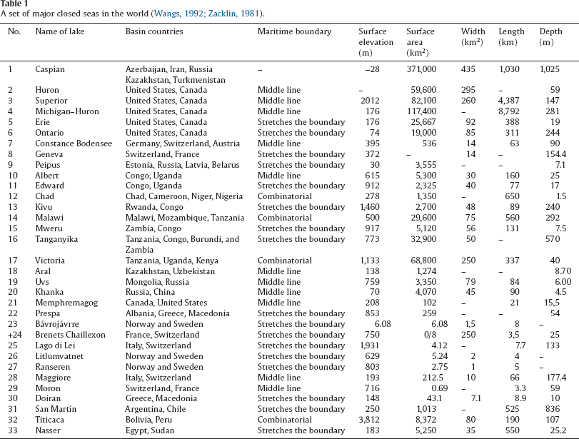
For example Lake Tanganyika is the longest lake in the world, and a variety of factors, in concert, make Lake Tanganyika an exceptionally rich and interesting ecosystem. Tanganyika is famous for their endemic species flocks of cichlid fishes, such as Lakes Malawi/Nyasa and Victoria. The African cichlid fish are the largest and most diverse radiation of vertebrates on earth. The countries of Burundi, Democratic Republic of Congo, Tanzania and Zambia share Lake Tanganyika. These four countries are among the poorest in the world. All of these countries need to use this resource, but the most important factor is sustainability development. For this, many national and international agencies have been put forward over the years to explain the extraordinary delimitation patterns in Lake Tanganyika. Finally, of the lake's shoreline perimeter, 9% is in Burundi, 43% is in D.R. Congo, 36% is in Tanzania, and 12% is in Zambia (Fig. 4) (West, 2001).
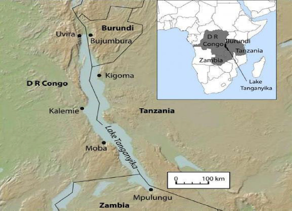
Lake Tanganyika and its riparian nations: Burundi, Democratic Republic of Congo, Tanzania and Zambia.
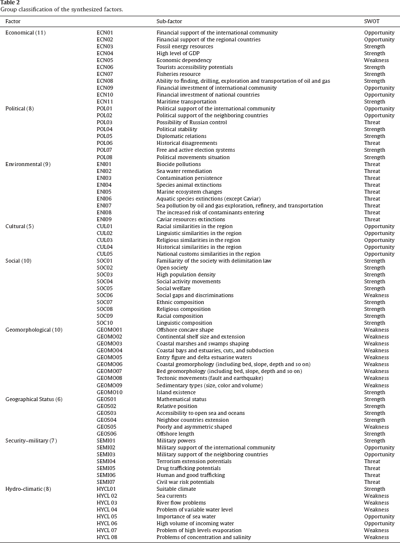
Another example is the dispute between the Republic of Malawi (“Malawi”) and the United Republic of Tanzania (“Tanzania”) concerning the location of the border between the two states on or at the perimeter of Lake Nyasa/Malawi (“the Lake”). The Lake is the third largest in Africa, sitting at the bottom of the Great African Rift Valley and covering approximately 29,600 square kilometers. The Lake's shoreline runs around western Mozambique, eastern Malawi, and southern Tanzania. The contestation relates to whether the boundary demarcating the parties’ sovereign territory or territorial waters runs along the middle of the Lake, or along the Lake's eastern shoreline of the territory of Tanzania. The dispute, therefore, relates to whether Tanzania or Malawi exercises sovereignty over the eastern half of the northern part of the Lake separating Tanzania and Malawi. The border dispute escalated in 2011 when Malawi awarded oil exploration licenses covering the disputed part of the Lake to Surestream Petroleum. Tanzanians depend on the Lake for food, transportation and other daily needs. The aggravation of Malawi's distribution of exploration rights based upon unilateral assertion of sovereignty elevates the parties’ interests by signaling potentially lucrative sources of government revenue. Possible resource extraction also signals potential threats to local and regional commercial, cultural and environmental interests. Further, failure of the parties to resolve the dispute via peaceful means may also lead to local and potentially regional insecurity, further harming the parties’ aforementioned interests. The dispute is complicated by historical shifts in the positions of the parties and the former colonial powers. Tanzania was a German colony until 1919 when it was awarded to Britain under the Treaty of Versailles, making it, like Malawi (then Nyasaland), a British territory. While the British colonial view of the boundary may have been inconsistent, the German and British authorities had formally agreed under the 1890 Heligoland Treaty (“the Treaty”) that the border ran along the Lake's eastern shoreline (Banda, 2013; Mahony et al., 2014). The effect of these problems on Caspian Sea delimitation is very critical because of the huge oil and gas resource, and the unexampled characteristics of the Caspian Sea. All experts, whether national or international, were characterized for the expert panel construction. One hundred eighty-seven deferent major factors were identified and generated, which were effective on the closed sea delimitation as an input to Delphi panel. In the first step, the DMs began their discussion of the issues relevant to developing strategic plan for optimizing the consensus on the Caspian Sea legal regime. Based on these discussions, the DMs collectively decided to consider the economic, political, environmental, cultural, social, geomorphological, geographical status, security–military, and hydro-climatic issues. The next steps involved a series of Delphi rounds to find a series of key relevant criteria for use in SWOT analysis. In the first Delphi round, the DMs were asked individually to consider the economic, political, environmental, cultural, social, geomorphological, geographical status, security–military, and hydro-climatic issues discussed in Step 1 and to compile a set of factors considered to be important in the delimitation decision. These personal lists were provided to the facilitator anonymously. Then, the facilitator combined all of these factors into a list with 187 factors. In round 2, this list was shared with all the DMs. They were asked to consider this feedback and then revise and resubmit their initial individual list. The facilitator combined all of these factors into a new list with 96 factors. Again in round 3, the synthesized list of factors from round 2 was shared with all the DMs, and they were asked to revise and resubmit their individual list from round 2. These Delphi rounds were repeated three more times. In round 3, based on these discussions, the DMs collectively classified the 74 factors developed in Step 3 into economics (11), political (8), environmental (9), cultural (5), social (10), geomorphological (10), geographical status (6), security–military (7), and hydro-climatic (8) categories (Table 2). At this rate DMs approved the validity of this list. So a decision was made to use the 74 factors issued in Table 2 in the subsequent steps. Then the DMs began their discussion of the relevant issues that affected the delimitation of closed sea in face-to-face brainstorming sessions. Based on the vast amount of information concerning the closed sea delimitation conditions, the DMs are determined the factors weight shown in Table 3. Also, the five coastal countries have been weighted based on these factors. The factor weights were achieved for each of the 74 components and the five countries as below:
Group classification of the synthesized factors.
Important weights.
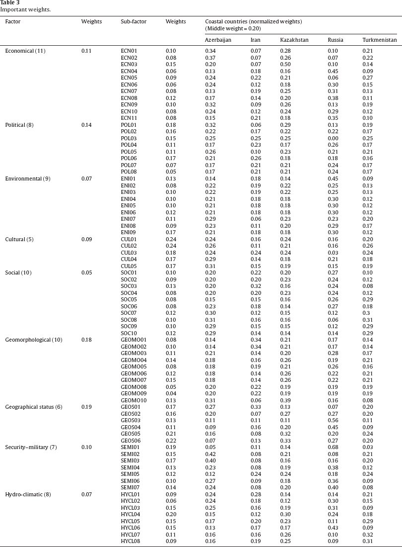
For each criteria: 
The above formula was applied to weigh the subcriteria where n is the number of subcriteria.
For each country respected to each subcriteria: 
SWOT analysis of external opportunities and threats, as well as the internal
strengths and weaknesses of the enterprises, is important for strategy
formulation and development. The analysis of external opportunities and threats
was targeting evaluation of whether an investment is able to seize opportunities
and avoid threats under uncontrolled external environment, such as waving
prices, political destabilization, social transition, and change in the rule of
law. And the goal of internal evaluation is to figure out how an investment
performs its internal tasks, such as management, work efficiency, research and
development, etc. (Chang & Huang, 2006). Matching key internal and external
factors is the hardest and challenging part of generating a SWOT matrix and
requires the discretion of the practitioner (Sevkli et al., 2012). DMs arranged
a classification of external or internal for the categories identified in the
last phase. Then the DMs classified external factors into two subcategories of
opportunities and threats and internal factors into subcategories of strengths
and weaknesses. Of the 74 factors presented in Table 3, 30 were classified as
external and 34 were categorized as internal. Within the external factors, 15
were perceived as opportunities and 15 as threats. Within the internal factors,
27 were identified as strengths and 17 as weaknesses. The balance of factors
between external and internal and threats and opportunities suggests a defensive
position in reaction to external threats rather than an offensive orientation in
the SWOT analysis. Those who participated in this program have been the subject
of a survey by a follow-up questionnaire wherein they were asked to score the
factors in each category on a scale of 0 to 1, with a 0.1 raise, where a score
of 0 indicates no significant and a score of 1 indicates extremely significant.
Table 3
presents the important weight assigned by each DM along with an average for the
all DMs. Then, for recognition of the key factors, the overall gap was
calculated: 
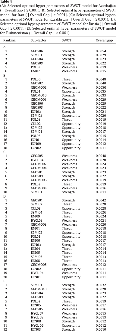
Then the DMs decided to annihilate those factors that they find moderately insignificant. For this reason, the DMs agreed to use a threshold of 0.001 out of a possible 1.0. Forty-four factors, including fifteen opportunities, ten threats, ten strengths and nine weaknesses, had a weight of 0.001 or greater, dispersed into five coastal countries: six factors for Azerbaijan, eighteen factors for Iran, ten factors for Kazakhstan, twenty factors for Russia and twelve factors for Turkmenistan. Some of these factors are alike for two countries, but their weights for all of them have differences based on their conditions. This resulted in a more manageable number of factors for the DMs to consider and a balance between the external and internal factors in the SWOT analysis. Table 4(A–E) shows the coastal countries according to key factors with │Overall Gap│ ≥ 0.001.
(A): Selected optimal hyper-parameters of SWOT model for Azerbaijan (│Overall Gap│ ≥ 0.001). (B): Selected optimal hyper-parameters of SWOT model for Iran (│Overall Gap│ ≥ 0.001). (C): Selected optimal hyper-parameters of SWOT model for Kazakhstan (│Overall Gap│ ≥ 0.001). (D): Selected optimal hyper-parameters of SWOT model for Russia (│Overall Gap│ ≥ 0.001). (E): Selected optimal hyper-parameters of SWOT model for Turkmenistan (│Overall Gap│ ≥ 0.001).
Strategy development is a very sensitive and complex procedure in which the alternatives are evaluated and the organization's resources are applied to achieve its mission (Li, Davies, Edwards, Kinman, & Duan, 2002). Due to uncertainty and perceived equivocation, developing strategy requires input and cooperation from many organizational functions and DMs (Eden, 1990; Li, Kinman, Duan, & Edwards, 2000; Mintzberg, 1994a, 1994b; Porter, 1987). SWOT analysis aims to identify the strengths and weaknesses of an organization and the opportunities and threats in the environment. To be aware of these factors can lead to developing strategies that may booster the strengths and annihilate the weaknesses, seize the opportunities, and counter the threats. An internal evaluation will reveal the strength and weaknesses of the organization and the external evaluation will do the same for opportunities and threat (Dyson, 2004). After these evaluations and selecting process, the DMs met to discuss the conclusions and finalize its recommendations. Next, the DMs arranged a series of additional face-to-face meetings to develop a set of strategies for exploiting the 44 critical success factors identified in the SWOT analysis. In three meetings, the DMs proposed 44 strategies corresponding to the theme in one of the critical SWOT factors. The proposed strategies are presented in Table 5.
Key strategies.
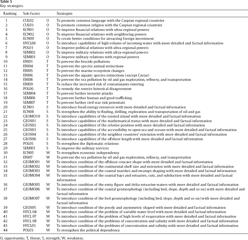
Key strategies.
O, opportunity; T, threat; S, strength; W, weakness.
Since the collapse of the Soviet Union in 1991, the Caspian Sea littoral states (Azerbaijan, Iran, Kazakhstan, Russia and Turkmenistan) have elevated from moderate equivocation to a remarkable distinction in international affairs. The Caspian Sea is a unique geographical and geopolitical phenomenon that requires a special international legal regime. Nowadays there is no substantial legal regime that is acceptable and applicable to coastal countries because the existing legal regime, which is based on the Russian Socialist Federal Republic and Persia (after 1935, Iran) on 26 February 1921, is not adequate to cope with today's political, economic, environmental and other problems.
One of the important factors that have increased the tension between Iran, Russia and the other littoral states is that it gives great weight to general Soviet–Iranian treaties that make little mention of the Caspian, and are completely silent about division or ownership of the seabed. Considering that the primary concern of the littoral states is the division of the seabed and the resources in it, the treaties appear to be useless. Iran argues for a common ownership regime of the Caspian's resources when in fact such a regime is not explicit in the treaties. Such a common ownership regime would, therefore, have to be inferred, but neither the Soviet Union nor Iran treated the Caspian as joint property during the Soviet era. The Soviets engaged in oil extraction activities outside the ten-mile exclusive fishing zone stipulated in the treaty, with no objection from Iran. Some have suggested that Iran's silence about de facto divisions during the Soviet era should preclude it from raising objections to national divisions today. Finally, Iran has refused to recognize the continued validity of the 1921 and 1940 treaties in other areas they govern, such as security. Although the littoral states around the Caspian may feel free to lay claims of exclusive jurisdiction over some sectors, “the legality of such claims may be tested by Iran as a matter of international law”. The lack of a systematic approach to the issue of competing sovereign rights of the littoral states, and the absence of an international adjudicative body with jurisdiction, is doomed to result in chaos, with an armed conflict lurking in the wings (Zimnitskaya & Geldern, 2011).
The Caspian Sea delimitation is a complex multi-criteria problem with conflicting objectives. It is hard to say for sure which delimitation is the best, but we made an optimal strategic planning by a hybrid model combining SWOT analysis with the Delphi method to assist the coastal countries’ negotiators to reach a significant consensus on the legal status and regime problems. The model decomposed the procedure into several steps and applied extracted key factors and developed key strategy from a set of closed seas with similar geographical features, which have already solved delimitation. For example a subcriterion that was suggested by the experts as an input to the model is Sea pollution by oil and gas exploration, refinery, and transportation subjected to ENI07. After SWOT analysis this item (importance ranking 33/44) was a weakness for Azerbaijan, and the recommended strategy was that this country should prevent sea pollution by oil and gas exploration, refinery, and transportation before the consensus on Caspian Sea legal regime. This strategy is comparable to the international and African organization request to change Malawi's recent decision to explore potential exploitation of the Lake's resources that became the tensions between coastal countries. It is of grave importance to choose an optimal strategy that can lead to profit or loss. They were convinced that the conclusion was unprejudiced and neutral and harmonious with their goals. However, the benefits of this model are yet nascent, and the potential is gigantic. Our contribution just addresses the set of problems that were recognized by DMs who were mainly Iranians. We are hopeful to be an inspiration for those who want to peruse additional research. However, we are optimistic that the legal status of the Caspian Sea will be defined in peaceful methods, which can be achieved by mobility, concurrence and rationality of the actions of all Caspian bordering states.